


Just another epic traverse in the White Mountains!
We Northeastern hikers are really gluttons for punishment, aren't we? I mean, what kind of masochist invented The Presidential Traverse or the Pemi Loop? Or there's the 50-Miler Hut to Hut Traverse, the Great Range Traverse or Kinsman-Cannon Traverse? Good grief, if you ever wanted to know how much pain and suffering can be fit into a one or two day hike, ask a White Mountain hiker. But all joking aside, there's something about doing those big traverses and summit challenges that makes it fun. So I'm going to slide another one by you- the Pilot-Pliny Range Traverse which climbs 2 4,000-footers, 4 of New England's 100 Highest and about a half dozen other "Puds" (pointless-up-and-downs). This trek brought me deep into the Northern Whites which was a spectacular wilderness.
Read. Plan. Get Out There!
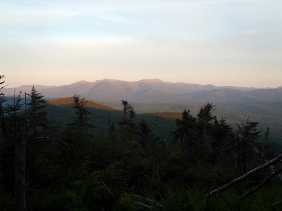 |
| Sunset on the Presidential Range from Mt Waumbek |
View Pilot-Pliny Range Traverse in a larger map
This particular trek has been done many times before but it doesn't enjoy the fame that the Presidential Traverse and Pemi Loop have. There's also probably a dozen different ways to do it. At some point in the trek, the following summits are climbed- Mt Waumbek, Mt Weeks-South, Mt Weeks, Mt Terrace, Mt Cabot, The Bulge and The Horn. All except for Mt Terrace are on the 100 highest list and Waumbek and Cabot are 4,000-footers. Its a nice way to bag a bunch of summits on the lists while enjoying the wilderness. While Cabot and Waumbek are frequently hiked, the trail is more or less of a route between the two.
I started from the South and, because I had no car shuttle option, it was to be an out-and-back hike. My plan was to leave from the Mt Starr King trailhead and make it all the way to the Mt Cabot Cabin on the first day. The second day I would hike Cabot, The Bulge, The Horn and hike all the way back to the trailhead. By my estimates, its about a 32 mile out-and-back trip but don't quote me on that!
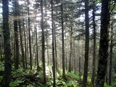 |
| The Northern White Mountain National Forest |
It was going to be a very tough hike, no matter which way I did it. The White Mountains may be shorter compared to other ranges in the West, but they are so rugged and steep that they compete for some of the most difficult hikes in the US. This one was no exception.
Leaving from the Starr King Parking Lot just outside of Jefferson, New Hampshire, I made the 3.4 mile trudge up Mt Waumbek. Its a pretty good trail- well marked and easily followed. After a couple of hours I was on the "summit" of Mt Starr King which is not a true mountain. However there is a very nice view just past the summit which overlooks the Presidential Range. Very photogenic. After about another mile I was on the summit of Mt Waumbek which was also nothing much. There was another view just past the summit with views though.
After leaving the summit of Waumbek, the trail became progressively more overgrown. South Weeks and Mt Weeks are both climbed somewhat irregularly by folks looking to bag New England's 100 Highest but do not expect the trail to be as nice and wide as it was on the latter summits. It was a bit of a trudge to get up both these summits and there's a nice PUD between the two that may leave you cursing this trip!
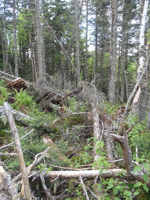 |
| This was "the trail" |
After passing over the forgettable summits of all the Weeks, the trail gets... interesting. This part doesn't appear to be maintained although there are yellow blazes which mark the way. At this point, it really does become more of a route than a trail and I would advise you to use caution. The route is easily missed and there were sections where I had to stop and use my map and compass. Some sections are fine, others are just hell. The picture above was taken on the Northern slopes of Mt Weeks where fallen trees completely obscured the trail for about half a mile and I was completely reliant on searching for those well-worn yellow blazes. Some profanities were uttered. You have been warned.
After coming down the summit of Mt Weeks, the trail meets the York Pond Trail at Willard Notch which separates Terrace Mountain from the Weeks-Waumbek ridgeline. The elevation is about 2,700ft, give or take which means that its a steep trail ahead of you or behind you. The trail becomes more of a trail again and climbs up to the summit of Terrace mountain, almost 1,000 vertical feet above the notch. There are some pretty views here too. The trail follows the Terrace Mountain ridgeline with a few minor summits along the way
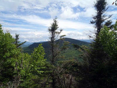 |
| Terrace Mountain Summit and the White Mountains Wilderness |
Coming down from Terrace Mountain is tough too- you drop about another 1,000ft to the Bunnell Notch separating Terrace from Mt Cabot. The Burnell Notch Trail is well traveled and you hang a left here to head up to Mt Cabot. At this point I was wicked tired but its still another 1,000 vertical feet to the summit of Mt Cabot. Hiking by headlamp at this point, I slowly made my way up the Mt Cabot Trail and finally arrived at the Mt Cabot Cabin. I promptly unpacked and was asleep before I hit the pillow. Its actually a nice cabin considering how far into the wilderness you are. You might want to still put your food in a bear canister as I understand there are some rodents up here that could chew through your backpack...
 |
| View from Mt Cabot Cabin! |
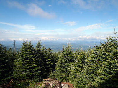
The next morning was gorgeous! I had a glorious view from the Mt Cabot Cabin and made breakfast and coffee at 4,000ft. The sun was out and the temperature was perfect. I headed off from the cabin and was on the summit of Mt Cabot in moments. From here I wanted to bag both the Bulge and the Horn. It was a couple miles further but I was not traveling with a backpack so it didn't take too long. The Bulge was completely viewless and forgettable but the Horn was phenomenal In fact, it was the best view on the whole hike. It was the classic 360-degree panorama with a hundred summits in view. I was glad I made the extra effort to get to the Horn from Mt Cabot. I would recommend it to anyone, whether your doing the 100 highest or just out for a hike of Cabot. It was the best view in the whole range!
Well from here, what can I say? I turned around and went back the way I came! I mean... it was a little more difficult than that sounds, but I didn't really have an option. I didn't run into any other hikers on the entire trip except for the Over The Hill Hiking Club out of Sandwich, New Hampshire. That was humbling- it was a seniors hiking club but most of the folks in it had hiked the 48 4,000-footers 6-8 times each! WOW! And I thought I was cool...
Its just a different breed of hikers out here in the Northeast!
Read. Plan. Get Out There!

1 Comment
backpackingamerica
September 12, 2013 @ 05:46
Beginners need to know about backpacking equipment, gear, supplies and essentials. Backpacking can turn into a horrifying experience if you're not prepared with the basics of backpacking.
backpacking tips