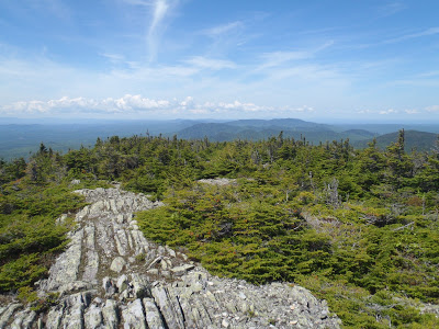
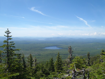
Boundary Bald, north of Jackman, Maine and just south of the Quebec border was one of the finest summits I've climbed in all of New England. It was tough to get to but its panoramic views of the Maine North Woods were unparalleled by any other summit I've climbed, short of Katahdin.
 |
| The incredible views on Boundary Bald, Maine |
Well I am hacking away at another peakbaggers list, again! Today its New England's 50 Finest Summits which is a collection of the most prominent summits in the region. I love climbing mountains on this list because I always end up climbing remote, rarely hikes summits which always turn out to be an adventure. As it turns out, Boundary Bald was on this list and its hike and view were like nothing I've ever encountered in Maine!
Boundary Bald is located off of Route 201, North of Jackman, Maine. Jackman kind of the last stop on the way to Canada and its definitely a border town. Its also a big logging town, hunting town and adventure town. I always love coming through Jackman because I know there's a bunch of kindred souls in that town who all love the rugged beauty of the Maine North Woods. Here is my hiking map so you can get an idea of how far out there it is-
So, yes, it is out there. Most people traveling through this area are loggers or hunters. Nevertheless, its a beautiful part of Maine that everyone should see. I was in this area for some river rafting and I had some extra time to do some hiking. Why not make some progress on New England's 50 Finest?
Like most mountains in Maine, getting to the trailhead is half the battle. So from wherever you are, you will need to get to Jackman Maine. Just as you cross the river, North of town, set the car odometer to zero. The turnoff for the trailhead is on an old logging road, 7.8 miles out of town towards the border on route 201. It is just past "The Falls Rest Area" and there is a small white sign which points the way. This is a logging road and while it could probably be cleared by a sedan, I don't like taking any chances with my car and I parked off to the side of the road on Old Canada Rd, just before the turn off. I mountain biked in- I just don't want to break down or get a flat on a logging road, if you have a 4x4 you will be fine. From Route 201, drive 4.4 miles down this road and don't get side tracked on the many unnamed roads in the area. Look for a little white sign that marks the Boundary Bald Hike.
 |
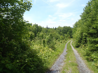
| ATV track just after the logging road |
After 4.2 miles, you will come to the turnoff for Boundary Bald. Hang a left on this road and drive about .2 miles further to a small "parking area" before the ATV Track. Unless you are *very* comfortable with your 4x4 skills, I'd recommend pulling off here. I dropped my mountain bike here and walked up the ATV Trail. The walk up the ATV Trail is not too bad but I would be a little hesitant to
drive up it. I would estimate that it was about 1.5 miles up this trail until the clearly marked trailhead.
Like I said, getting to the trailhead is half the battle.
 |
| Its a beautiful trail in some sections and its a murderous trail in others |
With these torrential rains that have left our 2013 summer with something to be desired, it was not surprising to have completely soaked trail. In fact, there was about a foot of standing water on the trail at the very start... welcome to hiking in Maine. From here the trail was basically cannibalized from a few mountain streams. There were blue blazes to mark the way but it got a little ambiguous in some sections. Just keep your head up as you walk and don't go too fast. There were some really pretty sections and several obligatory false summits to keep you on edge.
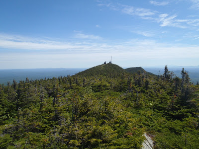
Eventually I popped out in the krummholz section of the hike and I knew I was getting close! The trail steepened, the vegetation more stout and thick and the views were phenomenal. I was at the "bald" part of "Boundary Bald" and I couldn't get enough of the views. The trail does get very difficult to follow as you top out though.
 |
| Somewhat of a peculiar sight on the summit of Boundary Bald |
 |
| I couldn't get enough of these views. This summit is magnificent. |
Crossing the trail through the thick summit vegetation offered views in every direction. I wondered to myself how this mountain wasn't climbed more often or why there wasn't a more established trail but I appreciated the solitude. There's just something different about climbing mountains in Maine as opposed to New Hampshire or Vermont. When I'm hiking in the Whites or Greens, its usually more of a social affair- I meet and talk with many other hikers who are just like me and out for a good time. Maine is different- even on the Appalachian Trail I hardly see other hikers and when I do, the conversations are terse. Silence and solitude are always in abundance.
This day was no different and I encountered no other hikers. I had that beautiful summit all to myself!
 |
| Coming down the mountain and trying to follow the blue blazes |
Coming down the mountain is always difficult- I wish I could waste the whole day just relaxing at the summit but alas, I have responsibilities back at home. It was a classic slip and slide on the way down but I was elated with climbing such a gorgeous mountain.
Climbing New England's 50 Finest is such a crazy adventure. Boundary Bald was probably one of the best I've done so far but I'm looking forward to further adventures and misadventures in wild places such as these. Whether or not you're a peakbagger, you should make it up to Boundary Bald sometime. Its too good to pass up.
Read. Plan. Get Out There!


3 Comments
Fran
August 9, 2018 @ 20:18
Thank you for this article. I was very pleased to have made this hike last week! It was challenging, but I did it. A first for me to attempt a summit. Do you have information on the distance from trail head to summit? I have seen conflicting info.
Thanks
Quincy Koetz
August 12, 2018 @ 14:43
Yes I remember distance being hard to track too! The actual trail at the end of the long-unused logging trail is 2.6 miles, round trip. However I think it really depends on how far you can get on the logging roads from Jackman for the true distance. At the time, I had a sedan without any clearance so I drove as far as I could on the logging roads, then mountain biked the last 5 miles to the “trailhead”. Without a doubt its one of my favorite hikes in the State; well worth the effort of getting there.
Michael Kenopensky
October 17, 2019 @ 13:57
It’s 1.4m on Trailroad , Then 1.3 to the helicopter pad at the Top, I drove .5m up the 4×4 road ..the ruts are deep and there is a boulder in the middle of the road, Heald Stream Falls is a nice spot for lunch on the way out…