A weekend spent in the Carrabassett Valley, Maine climbing Sugarloaf Mountain as well as West Peak and Avery Peak in the Bigelow Range
 |
| The rugged and frigid Bigelow Range, Maine |
Winter is fast approaching in the Northern Appalachian Mountains but its still possible to bag a couple summits without getting too technical! With Veteran's weekend approaching, I quickly drew up a trip plan which would further my progress into climbing all of New England's 50 Finest Mountains. This weekend's destination was the rugged ranges in the Carrabasset Valley region in Western Maine
This is a wonderful and wild part of Maine. Its similar to the White Mountains of New Hampshire with rocky, treeless peaks. Sugarloaf Peak is the second highest mountain in Maine and supports a large ski resort. The adjacent Bigelow Range is a tough, knife-edge ridge of summits that can be downright frigid throughout the year. Even in early November, there were layers upon layers of rime ice which allude to the sheer ferocity of the range's weather.
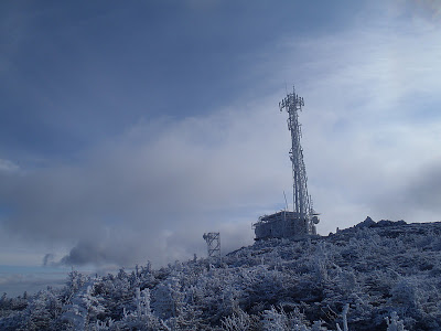 |
| The frigid summit of Sugarloaf Mountain, Maine |
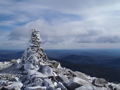 |
| Rime Ice on the Summit Marker |
I drove up to Carrabassett Valley on Friday and spent the night sleeping in my car. I decided I would try and use Sugarloaf's steep ski routes as a good place to do a shakedown for the mountaineering season. This isn't the normal approach up the mountain- the Appalachian Trail skirts around the summit and it can be hiked easily (
Link).
The ski resort isn't open yet so I thought that I would take advantage of this by climbing the routes. Unfortunately there was barely any snow at the lower elevations and just a light dusting up high! So instead of getting any mountaineering practice, I was simply climbing a steep hill. Oh well! It wasn't exactly a real wilderness experience but the views made the trip worth the trouble. Sugarloaf doesn't mind hikers, even during the ski season so if you'd like the repeat this, its completely okay.
Once I finally summitted, I was able to appreciate a view of nearly every 4,000 footer in Maine! Directly North was the Bigelow Range in all of its glory. Just a few miles West was the Crocker Range and Reddington. Saddleback and the Horn were to the Southwest and Abraham was to the South. The Appalachian Trail summits most of these mountains too! It made me wonder how difficult it must be to have traveled some 1,800 miles only to realize that the most difficult parts were still to come!
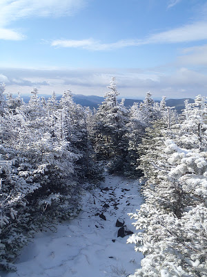 |
| Winter on the Appalachian Trail |
Just for fun I decided to follow the Appalachian Trail off of the summit. Despite the rime ice and freezing wind, the AT had a somewhat gentle look to it with the first winter snows. Some 10,000+ pairs of boots probably traveled this area this summer yet in the winter it hadn't even a footprint to mark the way. This trail, which has a life and culture of its own, seemed to have retreated into hibernation. There will likely be a few more rugged souls who climb the 4,000 footers in the winter, but it will remain rarely traveled until the snow melts. Of course, this further fuels my desire to climb more of the Appalachians in the winter!
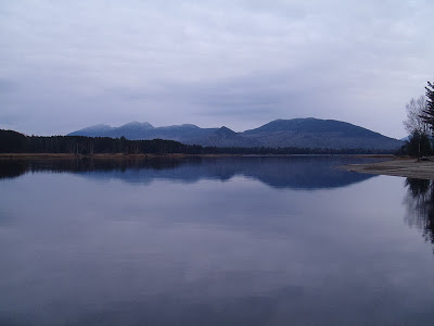 |
| The Bigelow Range from the town of Eustis |
After coming down from Sugarloaf, I decided to poke around the towns of Stratton and Eustis. These are mountain towns which are primarily inhabited by hunters during this time of year. I stuck out like a sore thumb! Here's this guy wearing Patagonia gear, without a single inch of orange, driving a sedan with California plates deep in the heart of the hunting capital of New England. I was positive I was the only person in a fifty mile radius without a pickup truck and the carcass of some animal on the roof. I swear I got the strangest looks- like "what God-awful wrong turn did you take to get out here, bub?"
Of course I haven't the slightest resentment of hunters! I'm actually developing a particular fondness for this part of Maine. I love Portland for the more unique, cultural, artistic and cosmopolitan side of Maine- I've already been wine tasting at a few of the downtown restaurants, frequented a few of my new favorite microbreweries and clubs in the Old Port and I'm a regular at the Portland Art Museum. Yet in the mountains and forests of Western Maine I've discovered the independent, self-reliant and very wild side of my adoptive state. Out here people hunt more as a way of living than for sport. One can bag enough meat to support a sizable family for the winter and a good-sized pair of antlers can sell for quite a bit of money. People hunt for the same reason they farm; its a source of income and a way to support a family.
 |
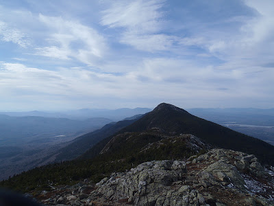
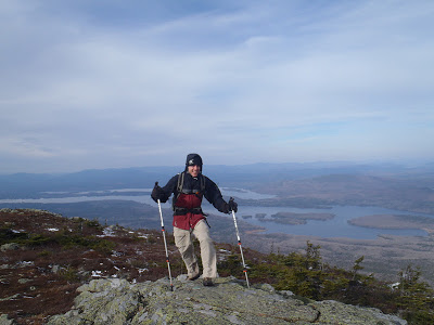
| West Peak (Right) and Avery Peak (left), Bigelow Range |
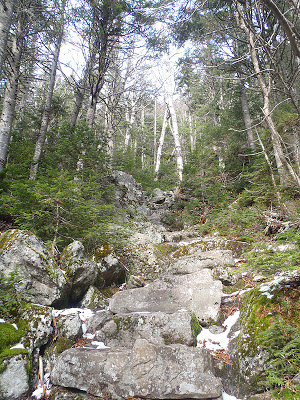
The next day was filled with an exciting and long hike in the Bigelow Range. It reminded me of the Presidential Traverse with large and steep gains and losses of elevation. I did the Fire Warden's Trail which is a shorter but steeper way of climbing the peaks (
Link). I'll post some very specific directions and instructions on how to climb this mountain too.
At the lower elevations I was walking through the now leafless forests. There was hardly any snow on the trail except near the summits. As I was hiking I heard the almost constant thunder of distant hunters. It was actually a pleasant sound- five miles away perhaps there was a tired, weather-worn hunter who finally got a kill. It's just a natural way of life out here. I really do hope to learn how to hunt someday.
 |
| Ain't no switchbacks out here! |
In classic, East-Coast fashion, the trail was extremely steep with no switchbacks which kills the knees and ankles! It took about half the day to reach the saddle. At the saddle the summit of Avery is 0.4 miles away and the summit of West Peak is a 0.3 mile hike. Both hikes were very enjoyable with stunning views of the whole Bigelow range and Flagstaff Lake. I was essentially alone and spent time on the summits just admiring the view. I'd highly recommend this hike to anyone who enjoys a challenge with rewarding views.
 |
| Almost getting blown off the summit of Avery! |
I almost considered trying to cross the summit ridges and all the way back to the Appalachian Trail but I was running out of daylight and decided to return on the Fire Warden's Trail. I did meet a few other ambitious hikers who were doing the full traverse which I hope to do someday in the future.
I hiked down and finally got back to my car an hour after nightfall. It had been a successful trip! I bagged two peaks of New England's 50 Finest and one more on Maine's 4,000 Footers. Of the two hikes, I preferred the Bigelow hike due to its views of Flagstaff lake and surrounding areas. However both hikes reminded me of how blessed I am to live in this rugged state. I'm looking forward to the winter and can't wait to start busting out my ice axe and crampons!
Read. Plan. Get Out There!


2 Comments
Jessica
December 1, 2011 @ 00:07
What a beautiful hike! I am your newest follower 🙂
Joe
December 1, 2011 @ 22:28
Thank you so much! Looks like you've been on quite a few adventures yourself 🙂