


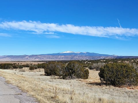
Mt Taylor is an imposing 11,000' stratovolcano dominating northwestern New Mexico. Visible from summits over 100 miles away, it's one of the most recognizable landmarks in the state. Mt Taylor has long been on my southwestern summits wish list given its aesthetic prominence over the desert. Unfortunately I'm usually in the area in the winter. With abundant research and preparation, I finally bagged it in January 2022. Here's my trip report.
Mt Taylor Directions, Logistics and Background
Mt Taylor is a beloved destination for any traveler to New Mexico. For peakbaggers and hikers, it has an impressive resume. It's #4 in topographic prominence for New Mexico Mountains (4,094' of prominence). It's also the highest point of the San Mateo Mountains, Cibola County and Cibola National Forest.
In any other season, Mt Taylor is a short but strenuous climb from the Gooseberry Springs Trailhead. Using trail #77, it's a 5 mile round trip hike with about 2,000' of gain. Forest Route 193 from NM-547 provides the best access to the trailhead although its a dirt forest road. Google maps will not get your there properly, be advised. The road to Gooseberry Springs is not maintained in the winter.
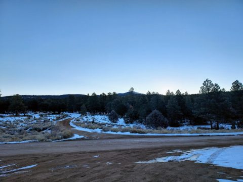
For winter travel, NM-547 is maintained from Grants, New Mexico to the end of the pavement. It's about 13 miles from downtown and an altitude of 8,200'. Past this point, the road is good quality dirt but not plowed or maintained in the winter. When I drove up here in January 2022 in a rental car, the road was ice free for another half a mile but quickly became snow-covered and slick. I simply parked at the end of the pavement and hiked in from there.
Snowmobiles and prepared 4x4 drivers will make it much closer to the summit but the area's remote with spotty cell phone reception at the lower altitudes.
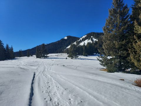
As far as winter routes go, it's a choice of how far to drive vs how far to hike in. If parking at the end of the pavement like I did, it's a slightly shorter round trip to hike up Gooseberry Springs road and then take the trail to the summit (16-ish miles). However the Gooseberry Springs trail is steep and shaded. I chose against it worried about powder and ice slowing my pace. So I hiked up NM-547 to FR-453 aka La Mosca Peak Road.
Here's my map:
Mt Taylor and La Mosca Lookout via FR-453
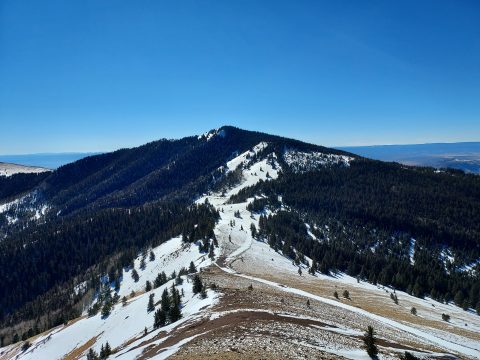
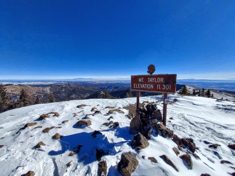
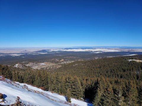
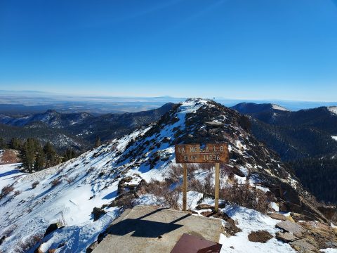
My route mostly followed snowed over forest service roads with trails near the summits. It's a very similar route to the Mt Taylor Quadrathalon each winter. My route was 19 miles with 3,700' of gain, all covered on foot. I hiked Mt Taylor, 11,301' and nearby La Mosca Lookout 11,036'. La Mosca Lookout is a summit with 471' of prominence and one of the few New Mexico summits above 11,000' outside of the Sangre de Cristos.
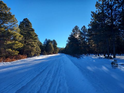
From the end of the pavement (altitude 8,230'), I walked 3.2 miles up the road to the obvious turnoff for FR-453 (altitude 8,780'). It was an icy road and certainly no place for a rental. I covered this distance in less than an hour in spite of the cold. Turning right on to FR-453 I followed this well-beaten road another 1.8 miles to a curious gazebo-like structure (altitude 9,460'). I believe it's a staging area for the Quadrathalon. There were tons of tire tracks up until this point though they quickly faded at higher altitudes. The gazebo is the highest point that people regularly take 4x4's up in the winter but I saw faint tire tracks up to about 10,000'.
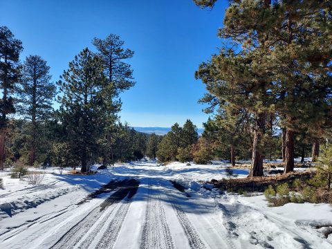
As the snow got deeper and tire-ruts faded, my pace slowed. It's 2.5 miles from the gazebo to the saddle (elevation 10,600'). After briefly stopping for lunch, I popped on snowshoes and headed towards Mt Taylor. The powder was much deeper on this part of the mountain. Although a trail connects the saddle to the summit, it was very hard to follow in the winter. Eventually I just gave up and chose my own adventure. It took me an hour to cover the final 1.1 miles between the saddle and Mt Taylor's summit (altitude 11,301'). My GPS showed a distance of 9 miles covered in 4.5 hours. Not bad for zero degree weather.
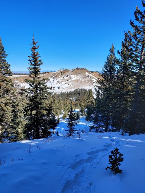
La Mosca Lookout and Descent
Exhausted and cold from the climb, I spent only minutes on the top before heading down. Though taking less effort, my pace hovered around 2 miles per hour down from saddle to summit. I considered bailing on La Mosca but it's exposed, south-facing slopes meant no deep powder. I took a direct route to La Mosca Peak from the saddle which took half the time as Mt Taylor.
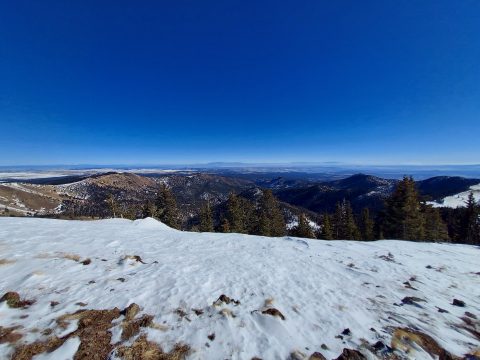
In spite of it's altitude, Mt Taylor has only directional views to the South, West and East. La Mosca Lookout had far more panoramic views, including that of Mt Taylor. It's worth the detour.
With daylight quickly ending, I kept up the pace on the descent. Snowshoes were not needed below 10,000' which was helpful. I made it back to NM-457 without incident and back to my car just as the sun set. My final GPS results were; 18.7 miles, 3,730' of gain over 9 hours and 20 minutes. Although I sure hope to hike Mt Taylor in a more favorable season, the winter climb was a splendid adventure.

No Comments