Mont Jacques-Cartier, at 1268m/4,160ft is the highest mountain in Québec outside of the Torngat Mountains. It can be relatively easily climbed in Parc National De La Gaspésie and presents a unique opportunity to see alpine caribou.
 |
| Mont Jacques-Cartier, Parc National De La Gaspésie, Québec |
After hiking
Mont Albert and the massive alpine plateau, I decided my next destination on the International Appalachian Trail/Sentiers International des Appalaches should be Mont Jacques-Cartier. This is the highest mountain of
Parc National De La Gaspésie. This was another mountain I've wanted to climb for a long time because of its prominence and status in Québec. I love that during my time living in the Northeastern United States I've been able to see and appreciate all the Appalachian Mountains from Connecticut to Québec. With the highest summit in the Chic-Choc Mountains under my boots, this would add to my appreciation.
Mont Jacques-Cartier is an interesting summit in the park because it contains a somewhat large heard of caribou which is not often found at these latitudes. As such, access to the summit is controlled and tightly regulated. You must take a bus from the Jacques-Cartier Campground because they do not allow parking at the trailhead. You can also take a bus from the visitor's center which saves you 40km of dirt road driving. Please
read this brochure if you are serious about hiking the mountain; there are many regulations.
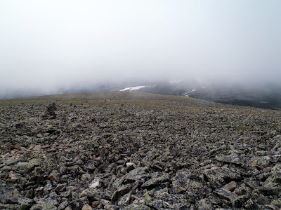 |
| Alpine Tundra at the summit of Mont Jacques-Cartier |
I elected to take the bus from the visitors center which was only 18 Canadian dollars, round trip. I didn't feel like driving a total of 80km of dirt road. Besides, I met many friendly people along the ride up. The park ranger accompanied us as well and although you could hike at your own pace, the mountain trails were only open from 10AM to 4PM and the summit had a strict turn-around time of 2:30PM.
It was a standard Appalachian Trail hike from the trailhead meaning that it was steep and slow going, but with plenty of sights to be seen along the way. It is a rough trail of mostly rocks so bring a solid pair of hiking boots. The total, round-trip distance is about 8.4km. After about a 2.4km ascent, there is a lovely little lake where you can eat lunch or relax before breaking tree-line and heading up to the summit.
After Lac a René, it is a 1.8km climb to the top of the mountain. Mercifully, there are steps cut into the trail which makes the going a little easier. When I was hiking, there was a thick fog which covered the mountain making for a strange hike. Towards the summit, there was just nothing but small, round rocks with little vegetation. It was mostly just lichen!
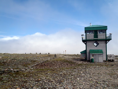 |
| The summit and shelter of Mt Jacques-Cartier |
Although it was late June, the summit was chilly and windy. While not surprising, it was nice to rest in the summit building while the rangers made a fire. I was glad I brought a fleece and some pants!
I decided since I still had some time that I would continue on the International Appalachian Trail for a few miles just to experience this unique alpine environment. Walking down from the summit towards Mont Comte was not too far nor difficult and I walked through more of the krummholz and across a few small glaciers. It is actually possible to walk from Mt Jacques-Cartier all the way back to the visitors center as a longer day hike but I was not prepared for this. However I would have liked to hike the IAT all the way across the park to get a full appreciation for these summits.
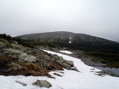 |
| Mt Jacques-Cartier from Mt Comte and a small glacier |
Eventually I had to turn back to make sure I caught the 16:00 bus back to the visitors center. I had thoroughly enjoyed this walk across the high summits of the Chic-Choc Mountains which felt much like the Presidentials of New Hampshire but more arctic. The trip probably seems random to most but for me it was exhilarating to have come this far north in the Appalachian Mountains. From here I would be driving the north shore of the Gaspe Peninsula towards
Forillon National Park. Although Forillon would be the furthest I would travel on this trip, I hope to someday climb the Appalachian Mountains of Newfoundland which would really complete my exploration of this magnificent mountain range.
Parc national de la Gaspésie is such an expansive park with hundreds of miles of trails. I clearly did not see enough in my two days here. As I have said many times in the past, I'm traveling so I can make a list of things to come back to someday. For now, I will be exiting the interior of the peninsula to see the St Lawrence seaway and coast.
Read. Plan. Get Out There!


1 Comment
Linda Jagger
February 3, 2024 @ 00:50
2/2/24 wonderful report, hope you still get comment. Live in Colorado USA, avid hiker, but am slow hiker since I’m 70.can do long hikes w/rocky terrain & 2000+ft gain. Have you returned to the park & hiked more-what other trails would you recommend? Do you know rules of getting camping reservations or is there a lodge to stay at?