


This is part of a series of posts of my 200 mile kayaking trip up the coast of Maine by the Maine Island Trail. Today I casted off from Portland and kayaked the Casco Bay. The first leg of a Maine adventure. Previously: My first trip on the Maine Island Trail
The time had come for me to finally start this voyage from
Portland. The day before, I drove up to Camden and purchased a 16’ yacht of a
kayak and all the required gear. I think it is impossible to live in Maine and
not have a desire to someday own a boat or a camp. It was only a matter of time
before this would happen. Some Mainers dream of owning a camp someday, I
dreamed of having a sea kayak. Seeing as it would bring me to some 200 islands
available for camping, I would say that I do own a camp.
 |
|
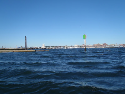
Casting off in Portland |
Up at 5:30am with everything packed, I drove out to the Bug
Light public launch in South Portland. For about an hour I played gear Tetris;
trying to shove a week and a half worth of supplies into one kayak tested my skills
of spatial perception. Fully loaded, I believe my kayak was somewhere between
120-150lbs. Normally before a grand trip I am brimming with excitement but
today I was apprehensive and edgy. Once I cast off from Bug Light, I would be
at the mercy of the Atlantic Ocean for the next week. So many factors played
into this trip of which I had no control. Godspeed.
View Casco Bay Kayak Route in a larger map
I’ve kept relatively quiet about this trip to most people
for fear that I would be telling friends about a grand adventure only to be
turned around 2 miles off the shore. To those I did tell, I publicly recognized that I could get turned around before making it to Peaks Island.
(just a mile from Portland). This is not feigned humbleness either- right off
the bat I was paddling perpendicular to the busiest shipping channel in the
state of Maine. Ocean going tankers regularly cross this channel and I doubt a
16’ kayak is going to alter their course. There were an infinite number of
boats who could crush me and they would be none the wiser. Out of the furnace
and into the fire. I vigorously paddled the mile long nautical superhighway
between bug light and Peaks Island hoping I didn't end up like a fly on a windshield. It was something like crossing a Boston freeway on foot during Friday
rush hour.
Well I made it to Peaks Island- one mile down,
one-hundred-and-ninety nine to go. At least I could say I didn’t get turned a
mile off shore.
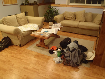 |
| Rough idea of what I packed |
“I am fulfilling at last a dream of childhood and one as
powerful as the erotic dreams of adolescence-floating down a river. Mark Twain, Major Powell, ever man that has
ever put forth on flowing water knows what I mean”
True, I am on no river, but the ever dependable Southwest
winds and currents of Maine fill my day with fair winds and following seas. I’m
just on a wider river.
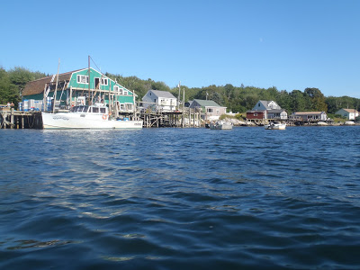
 |
| Harpswell and the edge of Casco Bay |
Unlike the Colorado River however, the Casco Bay is
populated and developed. For the most part I don’t mind it. I actually enjoy
the passive company of fellow mariners and vacationers. I’m far enough away
from each island and camp that I can sing songs or think out loud without
anyone hearing but close enough to feel the camaraderie of fellow ocean-goers. I
will not have this company the further I go.
From the bird’s eye view of a map, Casco Bay is easily
navigable but when your eyes are just two feet above the waterline, it can be a
maze. The whole coast of Maine is a navigational nightmare. I keep a constant
eye on my heading, use lobster buoys to judge the current and check the marine
forecast through my marine radio. I've been caught in high seas and thick fog
where getting lost is easy. Upon the horizon, the various islands and
peninsulas all blend into a green line which makes navigation that much harder.
I have no GPS but I feel growing confidence with the passing of every island. I’m
happy I forked over the extra cash for highly specific, waterproof marine
charts.
Rounding Harpswell neck I thread the needle in between
Bailey and Orrs Island which essentially is my exit out of Casco Bay. It’s just
about lunch time and I've paddled ¾ of the distance I planned for
day 1. Up till this point, things have been quite pedestrian. On the far side
of Casco, I’m at once more exposed to wind and current. The real trail has
begun. Although the winds and currents instantly became more serious, I was leaving behind the city and entering lobster country. The marinas, mansions and boat traffic thinned out and I began seeing more of Maine's thriving lobster industry.
Once I neared Phippsburg, the sun was setting and I camped out at a surprisingly developed campsite. Actually, it was more of a hotel except with tents. It had all the amenities of a hotel though: wifi, a restaurant, beach volleyball ect. How strange to be feeling like I am one a great wilderness adventure and to be staying at a posh campsite. I really had no other options and decided I would just deal with it.
I covered almost 30 miles on my first day. Not bad.
Next: Kayaking the Western Rivers and Boothbay Harbor
 |
| Lobster country |

2 Comments
Ksren
April 20, 2018 @ 03:07
Quick question
Did south to north seem like the better /easier choice?
Or did it really matter??
Quincy Koetz
May 5, 2018 @ 15:33
In the summer time, the winds seemed to blow consistently from the southewest and it was so dependable that I practically didn’t need to listen to the NOAA weather reports. I think going North to South would be significantly harder. Hope that helps!