After climbing the highest mountains of New Brunswick, the trail turns northeast and heads into the Gaspé Peninsula of Québec. The trail crosses Parc de la Gaspésie which preserves the high, alpine summits of Southern Québec. Mont Albert is a massive tundra plateau which resembles something North of the Arctic Circle.
 |
| Mont Albert in Québec is a unique sight to be seen this far south of the Arctic Circle |
Previous: Hiking Mt Carleton, New Brunswick.
Without a doubt, one of the highlights of the entire International Appalachian Trail is its traverse through the rugged Chic-Choc Mountains. This mountain range, which barely reaches 4,000ft (1,220m) is vast and barren on the higher peaks. At these latitudes, tree line can be quite low compared to other ranges. Today's destination was the massive alpine plateau which is Mont Albert. During the course of the hike, it felt like I was walking the frozen tundras of Northern Canada and I was able to capture some unique images which I doubt could be taken anywhere else.
Yesterday I had hiked
Mt Carleton in New Brunswick which is the province's high point. I spent the night in Campbellton, NB and in the morning headed to the Gaspésie! Again, I've wanted to travel to this wild part of Québec for so long now and I've finally made it! Driving along the southern shores of the Chaleur Bay was a glorious welcome. The bay is considered one of the
most beautiful in the world. The Chic-Choc mountains run right down to the shores and tiny villages hug the coastline. Every 20-30km or so, there would be a deep canyon where a river runs through and enters the bay. The drive was almost as nice as the hike! There are only a few roads which cut through the mountains and I took route 299 through the central Chic-Chocs to the park. This drive was also scenic as it followed the Cascapedia River deep into the mountains. I saw many fly fishers en route who were fishing for the river's
legendary Atlantic Salmon. So, for the thousandth time, I thought to myself, "Man, I need to learn how to fly fish". Another time, I suppose.
 |
| Parc National De La Gaspésie, Québec |
Parc De La Gaspésie is considered a national park of Québec although not a member of Parks Canada. Regardless, it was clearly a well-managed park with all the services of a regular national park. The visitors center was helpful with showing me where to hike and I was able to communicate well in English. Unfortunately, I do not know any French but the rangers and staff were quite cordial and friendly. I purchased a map, campsite and park admission and headed up Mt Albert.
The trail begins right near the visitors center and is easily followed. The one-way distance to the summit from the visitors center is 5.7km and there is a nice 1.1km walk that can be done past the summit which takes you across the plateau and should not be missed. Here is a general map-
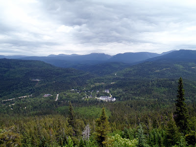
As you can see, its a steep ascent! The trail is cut right into the side of the mountain but it offers some views as you hike. The picture above was taken at the "La Saillie" view point which is about 1.1km from the visitors center. From here, I could see the high summits of the park including Mt Jacques-Cartier. Continuing up the mountain, the sights became more dramatic as I saw small glaciers and waterfalls tumbling thousands of feet down the mountain. I can only imagine how long it took water to carve out the many gorges on this side of the mountain.
It was a slow and steep ascent but in about 2.5 hours I was standing at the "summit" of Mt Albert. The true summits can not be reached because there are preservation efforts to ensure that the alpine environment can be enjoyed for years to come. This was unfortunate for peakbaggers like me, but I would hate to see such a delicate environment ruined by hikers so I was satisfied with the fake summit.
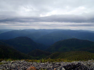 |
| Dramatic views from the summit |
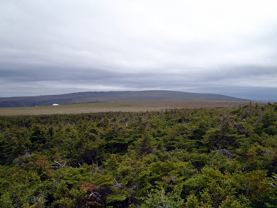 |
| The true summit of Mt Albert and the alpine tundra |
 |
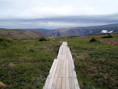
| Walking along the seemingly barren tundra of Mt Albert |
Just past the summit, the trail continued across the mountain and this was the most special part of the hike. It felt like walking in a desert! There were a few trees scattered about but for the most part, the vegetation did not grow taller than my boots. It was similar to the scenery of Mt Washington and the high summits of New Hampshire and Maine but flatter. There was just something magical about walking across this bizarre environment.
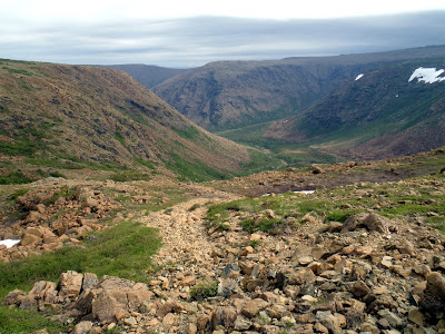
Just about 1.1km past the summit is a lookout area which views the canyon where the Diable River runs down-
 |
| Strange and wondeful |
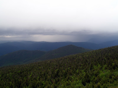
As I was just sitting and enjoying the view, I felt the wind change and I knew a thunderstorm was coming soon. A high, flat place such as this is no place to be caught in a thunderstorm so I quickly ran back to the summit cabin. I just barely missed the thunderstorm but I waited it out in the cabin. More interesting pictures were taken-
 |
| Thunderstorm moving quickly across the mountain |
 |
| The thunderstorm left as quickly as it came |
I wish I could have camped on this high escarpment where the mountain tumbles down into the river but there's no camping allowed in this particular area. I spent as much time as I could taking in the view before coming down the same way I came.
That night I camped out in the shadow of Mt Albert, next to the river. The clouds cleared and I saw the sunset on the mountain-
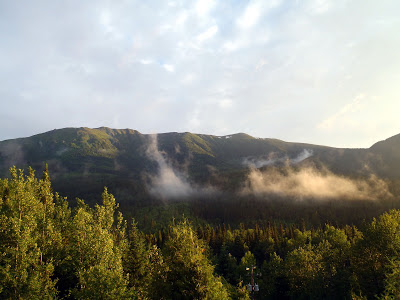 |
| Shadows and sunset on Mt Albert |
If the number of pictures taken is any measure of magnificence, Mt Albert would be the best of the whole trip. My camera was constantly out! Although Mt Albert is one of the most photographed parts of the park, the International Appalachian Trail crosses nearly every major summit of the park, including this one. I would have liked to start at the western end of the park and backpack for a week. This is commonly done, I am sure. Again, I am just making a list of things to come back for someday.
Next: Hiking Mt Jacques-Cartier: Highest Mountain in Southern Quebec.
Read. Plan. Get Out There!


No Comments