


A Comprehensive guide to the most unique mountaineering route in the world- Shorty's Well to Telescope Peak. From 250ft below sea level to 11,049ft. From desert sands to icy slopes, this route is certainly one of the greatest challenges in American mountaineering.
Heat exhaustion is hardly anyone's concern on a mountaineering expedition. Usually we pack enough cold weather gear to outfit a polar bear. But if you're climbing Telescope Peak from the floor of Death Valley, you have to have all your bases covered! In my experience as a climber, I could never write about a more unique and daring adventure. So here we go with a guide to climbing Telescope Peak.
Introduction to Telescope Peak
Death Valley is one of the most mysterious places one could travel to in the United States. Its full of unique phenomenon and unexplained natural mysteries. The origins and nature of sailing rocks of the Racetrack Playa continue to baffle scientists. The Ubehebe Crater reminds the visitor of the intermittent periods of volcanic activity that have also shaped this massive rift. And of course, Telescope Peak, at 11,043ft is often covered in a deep layer of snow while the valley below simmers at 100 degrees.
Telescope Peak itself was named from its incredible vertical relief. It rises over 2 vertical miles from the valley and at its summit, "you could see no further with a telescope". It is interesting to note that the roads which cross this range will have snow closures which is incredible considering one of the World's hottest temperatures was recorded just miles from this range.
National Park Website for Death Valley
Getting to the Trailhead
Getting there is somewhat difficult. First you have to get to the aptly named town of Furnace Creek, California. This is the only settlement in the area. A warning- gas in Death Valley is literally twice as expensive as the price of gas anywhere else in California. It was literally 6 bucks a gallon when I was there- gas up before entering Death Valley. Also, there is absolutely not a trace of cell phone reception ANYWHERE in the valley. You would be wise to pack survival gear in your car because you never know what could happen here and services are few and far between. I busted a flat and got a dead battery on the same trip on one occasion! (a story for another time). HERE are the Directions!
Here is another topographic map of the route.
Logistics
...Where to begin?? This trip is a logistical nightmare. My pack weighed upwards of 35lbs which is astronomical for a weekend trip. You really have to pack as if you're going on two separate trips. Not only that, but with only one water source on the whole trip, you need to carry well over 3 liters of water. The variability of the terrain and the need for extra supplies makes this trip a 2 to 3 day excursion for the experienced backpacker.
I'll make the assumption that if you're reading this, you know to bring the basic essentials and I'll just go over additional things. For the desert portion, you need lots and lots of water. It can be anywhere from 60-95 degrees in the winter which is when this trip should be done. So of course, don't forget sunscreen and a hat. As far as the climbing portion goes, you will definitely want to bring trekking poles, an ice axe and even snow shoes or crampons. When I did it, I brought crampons and was post-holing at 8,000ft. Bring some warm weather gear too because even at the lower elevations it can get below freezing at night.
Of course, don't forget to bring a water purification system. Iodine should be fine.
While heat related dangers are your concern at the lower elevations, the mountain range holds an entirely different set of dangers which need to be accounted for in planning. At the foot of the range, you will be traveling through a very deep canyon. Flash floods are possible any time of year and it does rain occasionally in the winter. Towards the alpine zone, there are some areas of avalanche danger. The extreme temperature differences make this danger even more real- know the signs. When you're in the mountains, try and forget that you just traveled through the hottest, driest place in North America and act according to your knowledge at hand! You really should have extensive experience with backcountry desert travel and mountaineering experience- both with serve you well in this wilderness.
If you were to get injured or incapacitated... there's absolutely no cell phone reception or any chance of seeing anyone on this route- you might as well be in Alaska. Plan accordingly...
Here is a summitpost article about the route which will also aid in your planning of this expedition.
There should be a very faint trail just beyond the end of the 4x4 road and this can be rather ambiguous. It will lead you through the canyon and eventually to a fork. Take the left/South fork which is the larger of the two canyons. It is VERY IMPORTANT that you follow this canyon because there is ONE WATER SOURCE! Hanaupah Springs is an above-ground spring which is available all year long. Any old water filter will be fine. Do not miss this one opportunity for water. There may be snow at higher elevations which you can also melt, but this spring is very reliable.
 |
| The Most Unique Climb in America |
Introduction to Telescope Peak
Death Valley is one of the most mysterious places one could travel to in the United States. Its full of unique phenomenon and unexplained natural mysteries. The origins and nature of sailing rocks of the Racetrack Playa continue to baffle scientists. The Ubehebe Crater reminds the visitor of the intermittent periods of volcanic activity that have also shaped this massive rift. And of course, Telescope Peak, at 11,043ft is often covered in a deep layer of snow while the valley below simmers at 100 degrees.
Telescope Peak itself was named from its incredible vertical relief. It rises over 2 vertical miles from the valley and at its summit, "you could see no further with a telescope". It is interesting to note that the roads which cross this range will have snow closures which is incredible considering one of the World's hottest temperatures was recorded just miles from this range.
National Park Website for Death Valley
 |
| Badwater, Death Valley to Telescope Peak |
Getting there is somewhat difficult. First you have to get to the aptly named town of Furnace Creek, California. This is the only settlement in the area. A warning- gas in Death Valley is literally twice as expensive as the price of gas anywhere else in California. It was literally 6 bucks a gallon when I was there- gas up before entering Death Valley. Also, there is absolutely not a trace of cell phone reception ANYWHERE in the valley. You would be wise to pack survival gear in your car because you never know what could happen here and services are few and far between. I busted a flat and got a dead battery on the same trip on one occasion! (a story for another time). HERE are the Directions!
View Untitled in a larger map
Here is another topographic map of the route.
Logistics
...Where to begin?? This trip is a logistical nightmare. My pack weighed upwards of 35lbs which is astronomical for a weekend trip. You really have to pack as if you're going on two separate trips. Not only that, but with only one water source on the whole trip, you need to carry well over 3 liters of water. The variability of the terrain and the need for extra supplies makes this trip a 2 to 3 day excursion for the experienced backpacker.
I'll make the assumption that if you're reading this, you know to bring the basic essentials and I'll just go over additional things. For the desert portion, you need lots and lots of water. It can be anywhere from 60-95 degrees in the winter which is when this trip should be done. So of course, don't forget sunscreen and a hat. As far as the climbing portion goes, you will definitely want to bring trekking poles, an ice axe and even snow shoes or crampons. When I did it, I brought crampons and was post-holing at 8,000ft. Bring some warm weather gear too because even at the lower elevations it can get below freezing at night.
 |
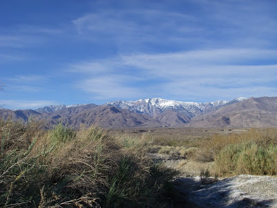
| The Panamint Range, Death Valley, California |
While heat related dangers are your concern at the lower elevations, the mountain range holds an entirely different set of dangers which need to be accounted for in planning. At the foot of the range, you will be traveling through a very deep canyon. Flash floods are possible any time of year and it does rain occasionally in the winter. Towards the alpine zone, there are some areas of avalanche danger. The extreme temperature differences make this danger even more real- know the signs. When you're in the mountains, try and forget that you just traveled through the hottest, driest place in North America and act according to your knowledge at hand! You really should have extensive experience with backcountry desert travel and mountaineering experience- both with serve you well in this wilderness.
If you were to get injured or incapacitated... there's absolutely no cell phone reception or any chance of seeing anyone on this route- you might as well be in Alaska. Plan accordingly...
Here is a summitpost article about the route which will also aid in your planning of this expedition.
 |
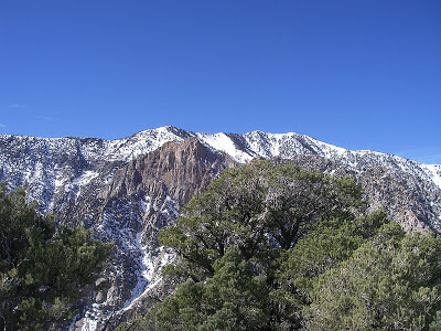
| Through the desert and on to the mountain! |
Across Death Valley and into Hanaupah Canyon
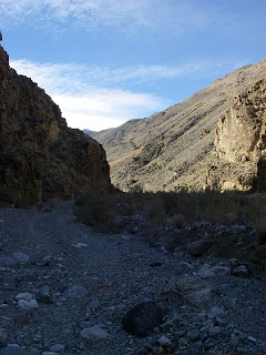
The Shorty's Well parking lot will serve as a trailhead and a 4x4 drive trail leads directly towards the mountains. This road is known as Hanaupah Canyon and is a very technical 4-wheel drive trail. It ascends about 4.5 miles to the foot of the Panamint Range and the destination of Telescope Peak. This is a light ascent and it brings you to the end of the road at about 1,800ft. From here you follow the canyon as it meanders through the mountains for a couple miles.
There should be a very faint trail just beyond the end of the 4x4 road and this can be rather ambiguous. It will lead you through the canyon and eventually to a fork. Take the left/South fork which is the larger of the two canyons. It is VERY IMPORTANT that you follow this canyon because there is ONE WATER SOURCE! Hanaupah Springs is an above-ground spring which is available all year long. Any old water filter will be fine. Do not miss this one opportunity for water. There may be snow at higher elevations which you can also melt, but this spring is very reliable.
 |
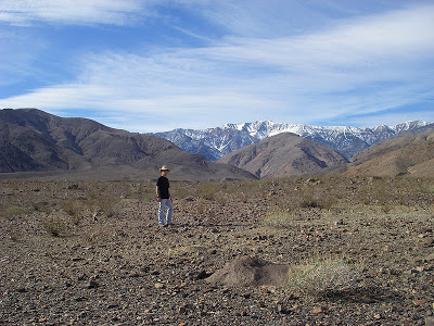
| Hanaupah Canyon Trail, looking towards Telescope Peak |
 |
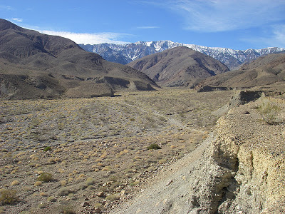
| The end of the 4x4 Trail in Hanaupah Canyon |
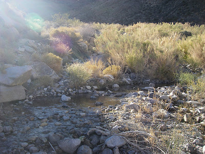 |
| Hanaupah Springs which can be easily missed if you're not looking for it... |
Keep in mind that there are many long abandoned mines and mining roads in the area that can confuse you. The mines are very interesting to check out, but the roads DO NOT climb to Telescope Peak.
After filling up as much as you can on water, you're going to be trying to ascend the ridgeline directly North of you (on the right!). If you're tired, there are some spotty campsites around Hanaupah springs. There might even be some opportunities to see some wildlife. The ridge is a class 2-3 scree slope that would be made easier with trekking poles. This climb is not technical but it is frustrating and challenging. Don't be surprised if you get into patches of "one step forward, two steps back". Once on top of this Ridgeline, there are other spots for camping.
 |
| Death Valley |
The ridgeline itself heads towards a saddle between Telescope Peak and the rest of the mountains. Its not a straight shot although it would appear as such on the map. The terrain is variable and there are sections of descents and ascents. Its also a very exposed ridgeline and you'd want to be careful of the few weather systems that affect the area. Again, it snows enough up here to close some roads!
Eventually you will reach the saddle between two mountains- Rodger's Peak is to the North and Telescope Peak is to the South. Take this ascending ridge until you are at the true summit. Its somewhere in the neighborhood of 15 miles from Shorty's Well to the summit.
 |
| Death Valley from the Panamint Range |
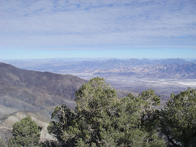
Once you've finally summited, you can enjoy a very unique view! Sometimes you can see all the way to the Sierras! This is also the best place to appreciate the tremendous depth of Death Valley. Considering this was a major hub for mining, there must have been something really valuable to cause people to live and work in such a ruthless environment. The mines are all dried up, but there still something of value that us climber types look for in this ultimate wilderness!
Read. Plan. Get Out There!

4 Comments
Eric Y
May 29, 2012 @ 06:16
Great report! Do you have a GPS track that you can share?
Joe
May 30, 2012 @ 03:59
Ah I actually don't! That would be really helpful though, I'll have to keep that in mind for the future.
Joseph Gregory
February 22, 2016 @ 19:11
Do you do a point to point (Shorty's-Telescope- pickup car at Mahogany Flat) or an out and back?
Quincy Koetz
February 24, 2016 @ 11:40
Most people that I've spoken to or heard from prefer the car shuttle- Shorty's Well-Telescope to Mahogany Flat. I was on my own so I just did the out and back. Either way is a grand adventure!