Mt Timpanogos is neither the highest nor the most prominent in Utah but it is certainly the most infamous summit of the state. It remains a favorite of both casual and hardcore hikers.
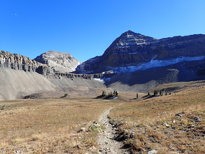 |
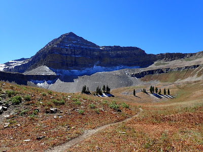
| Classic view of Mt Timp's impressive head-wall and glacier |
 |
| First view! |
If we were to compile a list of the most well-known mountain of every state, it would not simply be a list of the tallest or most massive. Certainly the record-breakers of Mt Whitney, Mt Hood and Mt Rainier would make the list. But so would Mt Timpanogos, Mt Clark (NV), Mt Rushmore, Camel's Hump (VT), Stone Mountain (GA) and Lookout Mountain (TN). None are remarkable in terms of elevation compared to their state's highest mountains. Why the tallest mountain isn't necessarily the most famous is an interesting blend of lore and geography.
Mt Timpanogos is the second highest mountain in Utah's Wasatch range and not nearly as tall as the state highpoint of King's Peak. Nevertheless, its imposing ridge dominates the Wasatch Metro Area and is far more sought-after than nearby Mt Nebo.
While this trail is probably the most heavily trekked in this part of the state, it is still considered strenuous. Starting at about 7,400' and topping out at 11,752' in 7 miles is no easy affair. Its an all day hike for just about every hiker. Water sources exist at the lower elevations but become scant after 9,000's.
It might not be evident on the topographic map, but the elevation gain of the trail is more like a staircase than a constant uphill. There aren't any flat sections but there's many sections of steep ascents and comparatively lighter elevation gain. The pace of the trail is somewhat modulated by this.
 |
| At the lower elevations |
 |
| From the summit, looking down at the glacial basin |
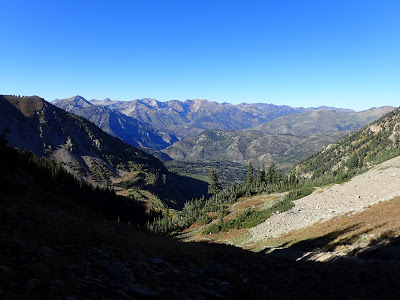
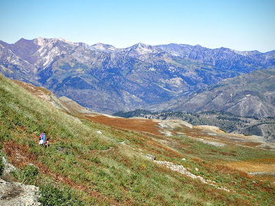
In the first mile, Scout Falls can be seen by taking a 100-yard detour. The falls are about 30 feet tall and are a nice spot for a break in the hiking. The trail continues a series of quick bursts of elevation and plateaus which offer panoramic vistas of the northern Wasatch summits near Park City.
Imposing subsidiary summits dominate the skyline as the trail continues to switchback in a southerly direction. There isn't a single point on the trail where there isn't a magnificent view which is probably why it is so popular. Despite the crowds at the trailhead, the trail itself is long enough that the crowds quickly thin out and I was mostly alone on the trail. Saturdays are, of course, quite busy but any other day of the week makes the trail feel empty.
From roughly 8,700' to 10,000' the trail gains steady elevation until the sharp summit of Mt Timp comes into view-
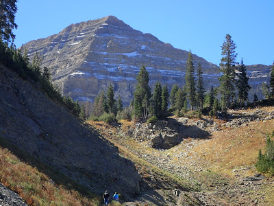 |
| Mt Timp, striated with snow and rock, even in mid-September |
The glacial basin below Mt Timp is about as scenic as the summit itself and it would not be unfortunate if this ended up being a turn-around point. Utah's only glacier is plainly visible off to the southeast as is a significant portion of the Wasatch Range. I stopped for lunch here and enjoyed breathing the crisp alpine air.
A notch is visible separating Mt Timpanogos from the other northern summits and this is where the trail eventually leads. It continues to swtichback and climb the steep face of the ridgeline but its never more than a Class I hike. Another popular lunch spot is the notch itself which is at 11,000' and about 45 minutes away from the top. From here, the entire front range metro area is visible as well as Utah Lake. Its a fantastic albeit crowded spot.
 |
| Plateau before the final push for the ridgeline |
 |
| No shortage of views |
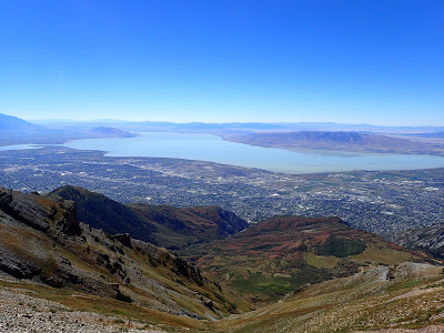 |
| Utah Lake and the Wasatch front metro area |
 |
| The notch before the summit- a very popular resting point |
The trail to the summit from the notch may be harrowing for some. Its exposed and on lose rock in some sections- I would recommend hiking poles here. There aren't any particularly cliffy sections but a slip could still be dangerous. Temptingly close, the summit is still a struggle to get to. Even for this experienced hiker, I found myself stopping often to catch my breath in the thin air. The trail gets congested towards the top as hikers slow down due to the strenuousness of the climb and tricky footwork.
Finally at the top, there's a curious pyramidal shelter with a summit register. No fewer than two dozen people were at the summit on this fine, early-autumn Sunday and I'm sure it gets much more crowded on Saturdays. Nonetheless, the views were phenomenal, as expected. Its easy to appreciate the glory of Utah's most famous mountain at this point. Even I was a little squeamish looking down from the head-wall over the glacial basin.
Despite the crowds, most other hikers were well behaved and respectful of the mountain. Other popular mountains I've hiked have had a higher ratio of totally oblivious day trippers; on this mountain, most people were pretty courteous. I made some new friends on the trail.
 |
| Looking back towards the ridgeline |
I liked this hike- normally I don't like ultra-popular hikes. But this was a long enough trail to keep out most of the riff-raff and challenging enough to keep me motivated. I would certainly hike it again when I'm back in Salt Lake City. The alternative route though aspen grove looks equally enjoyable. I wish I lived here!
Read. Plan. Get Out There!


No Comments