Flat Top Mountain is the prominent yet obscure high point of the Oquirrh Mountains which overlook the Salt Lake Valley and Lake Utah. It is an infrequently climbed mountain that is publicly accessible through a hike that crosses both public and private lands.
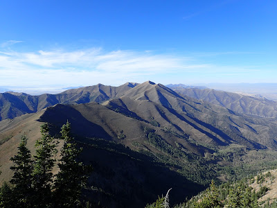 |
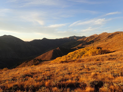
| View from the Summit |
Flat Top misses most people's radars when there's already a massive network of trails in the nearby Unitah National Forest. As a stand alone summit, the mountain is impressive. It tops 10,620' and has 5,370' of prominence (more than Mt Timpanogoos). The greater Oquirrh Range is more famous for the collosal Bigham Canyon Copper Mine, the largest open-pit mine in the world.
The majesty of the Oquirrahs is more well known for their abundant natural resources which have caused significant development, especially on the northern part of the range. Ophir itself is a relic of a long-gone age of smaller, independent mining. These days the massive operations of Bingham Canyon Mine and Mercur Mine continue. However this trail tends to stay in the wilderness portion of the range which keeps the larger areas of development hidden.
Hiking up the mountain is pretty straightforward by Utah standards. Its about 9 miles round trip and involves significant elevation gain. Here is a map-
The trail begins just northeast of the town of Ophir, Utah. Note the road does become dirt/gravel outside of the town limits. Free range cattle roam the road and may or may not move for your car. The parking area is public and there's plenty of space. Check for any signs of changes in landownership or restrictions on hiking before you go. Note that the path taken above is the most common ascent up the mountain. Other ascents are possible but they have not always been open or legal- if you deviate from this route, make sure you have necessary permissions.
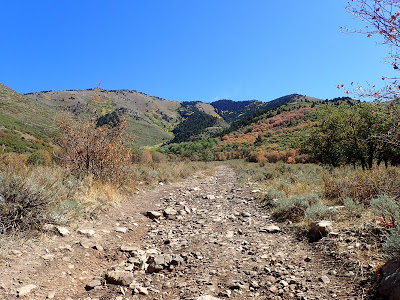 |
| The trail is a slow incline at first. The summit is not visible in this picture |
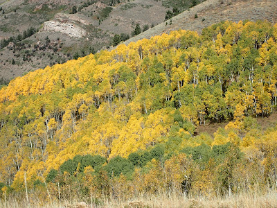 |
| Glorious colors this time of year |
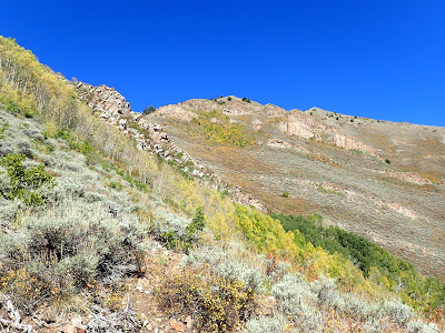
Initially, the trail sets a steady pace of climbing as it seamingly veers away from the summit. This is a wide, 4x4 road that is likely only passable by boots and ATVs. As it turned out, I was the only one on foot today although a thundering heard of ATVs wound around the trail on their way to Porphyry Hill- another popular destination. Once the trail reaches the saddle, there's a 4 way crossing. Heading to the left takes the hiker towards the rideline and summit. The trail quickly ends and becomes more of a herd path. It is easy to miss the beginning of the herd path but it starts at the very left side of the dead end ATV road.
From here the trail gains quite a bit of elevation through many switchbacks. I imagine multiple routes exist here as the trail is unmarked and not very trod. Thick, spiny desert plants make long pants a necessity, even in the heat of the summer. High top boots are helpful as well. The trail switches back endlessly as comes up to 9,000'.
 |
| Flattening out and taking a first look towards the Unitas |
 |
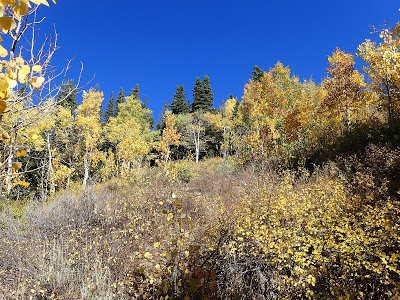
| Fall colors vary by elevation |
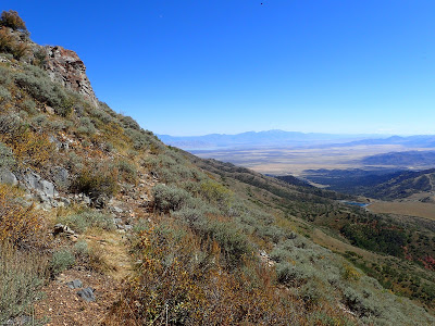
From here the trail hugs the mountainside and generally doesn't gain nor lose any elevation. This part can be confusing as it seems that the hiker will miss the summit entirely. It dips a little bit before coming though a creek area lined with dense foliage. Views of the nearby Unitas and Utah lake become outstanding on this section. Fall colors continued to permeate the otherwise stark desert landscape. The trail sharply doubles back at the far ridgeline and climbs to a saddle.
Though scenic, the trail from the saddle to the peak is very rough and mostly unmarked. Again, numerous networks of trails exist and not all of them are cleared. Stickers and sharps were common and I was again thankful for long pants, high socks and high boots.
 |
| Autumn colors |
 |
| Autumn Colors |
 |
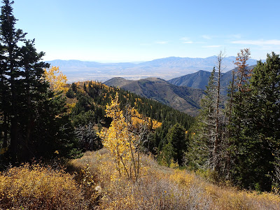
| The rest of the range visible from near the summit |
Several false peaks keep the hike going before topping out on the bare summit. Flat top is somewhat flat with an antiquated radio tower at the top. The summit log is in a mailbox and most the signers are local hunters. There were a few signatures from folks like me who were going for the "America's Ultras" challenge of climbing all 57 Ultra-prominent peaks. No doubt I would have missed this mountain myself had I not been on this quest.
Views are phenomenal, naturally. The whole of Utah Lake is plainly visible as are the rising summits of the entire Unita Range. Mt Nebo's pyramidal spire appeared as a razor's edge in the distance. To the west was the summit I climbed three days prior- Deseret Peak and the rush valley separating these ranges. Fortunately, none of the large mines of the range were visible. Flat top retains its wilderness character on this hike.
The way down was the same although I've heard that loop hikes exist. Again, always check permissions first as the majority of the land around Flat Top is privately owned. People have been cited and fined for trespassing in this area.
 |
| Last look at fall color |
 |
| At the summit |
Overall, its a pretty straightforward hike. It pales in comparison to the more rugged summits of the Unitas and the Deseret Range but its an enjoyable hike nonetheless. I don't think I'll remember it as fondly as I do Mt Nebo, Mt Timp and Ruby Dome but I would hike it again.
Read. Plan. Get Out There!


No Comments