


Mt Everett is another hidden gem that's rarely seen by people not hiking the Appalachian Trail. AT 2,624ft, it is hardly on anyone's radar as worth hiking. However the summit supports a surprisingly alpine environment as well as better views than Mt Greylock.
Day 4:
Miles: 510
I somewhat ceremoniously said goodbye to New England when I crossed Lake Champlain on the ferry. However I suppose I wanted a little more so I came down from the Adirondacks, followed the Hudson River and then crossed over in to western Massachusetts to the Taconic Range. It is funny how essentially everything west of Springfield is considered "The Berkshires" even though much of the western mountains are actually part of the Taconic Range. Mt Greylock is not only part of the Taconics, it isn't even the tallest one! That honor belongs to Mt Equinox in Vermont. Regardless, Mt Everett interested me because it is a large plateau spanning the NY/CT/MA lines and has an unusually alpine flavor to its rather low altitude. Several pockets of wonder exist in the area which is why this seems to be Massachusetts' best kept secret.
Here's an area map but know that multiple trails exist for summiting-
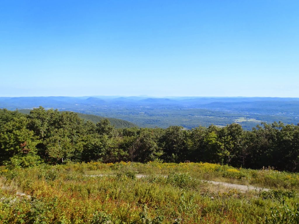 |
| Expansive views from this relatively low summit |
Miles: 510
I somewhat ceremoniously said goodbye to New England when I crossed Lake Champlain on the ferry. However I suppose I wanted a little more so I came down from the Adirondacks, followed the Hudson River and then crossed over in to western Massachusetts to the Taconic Range. It is funny how essentially everything west of Springfield is considered "The Berkshires" even though much of the western mountains are actually part of the Taconic Range. Mt Greylock is not only part of the Taconics, it isn't even the tallest one! That honor belongs to Mt Equinox in Vermont. Regardless, Mt Everett interested me because it is a large plateau spanning the NY/CT/MA lines and has an unusually alpine flavor to its rather low altitude. Several pockets of wonder exist in the area which is why this seems to be Massachusetts' best kept secret.
Here's an area map but know that multiple trails exist for summiting-
View Hiking Mt Everett in a larger map
If you zoom out on the topographic map, you can see how the entire area is somewhat of a diamond shaped plateau. Mt Everett rises sharply from the valley below but exists only as a slightly higher peak in an area of peaks which are all similar in elevation. The Appalachian Trail crosses the entire range and many say this is the best area of Massachusetts and Connecticut. I would tend to agree.
I parked at the bottom and took my mountain bike up the old auto road to the Appalachian Trail. It wasn't that I couldn't just drive up this part, I just felt like getting my bike off the top of the car for a while. It felt good although being in hiking shape and mountain biking shape are quite different and I am not in the latter!
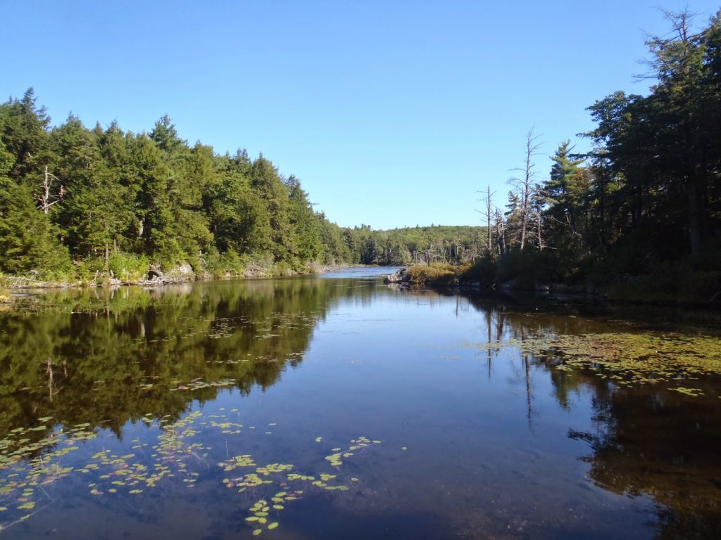 |
| Guilder Pond is the highest pond in Massachusetts |
I came across Guilder Pond which looked very similar to what could be seen in the Whites or Greens. I would have hiked this area just for the view of the pond.
From here, the parking area is just beyond and this is the highest you can drive. There are water jugs but they are for thru hikers only. The Appalachian Trail heads almost directly up the mountain. I decided to mountain bike the rest of the auto road which became significantly more deteriorated as I got to the end of it. There is a lovely stone shelter for AT hikers at the end of the decrepit road and the Appalachian Trail continues to the summit. It didn't take more than 20 minutes to get to the summit from here.
There's a well documented grouping of stunted pitch pines at the summit which is very rare for this area. Pitch Pines dominate some of the summits further south, as well as the Jersey Pine Barrens. Nevertheless, the entire flora of the summit was stout and scrubby. I've climbed mountains that are twice this high and didn't have quite the alpine feel that Everett did. A southbound AT hiker was on the summit and he happened to be a forestry expert who confirmed how exquisite this environment is at these low elevations. We geeked out a bit.
 |
| Pitch Pines |
 |
| Summit views of Mt Frissell, CT |
 |
| The scrubby flora crowds in on the AT |
Later that same day, I would end up hiking Bear Mountain in Connecticut which had a similar feel. I hiked the area a year ago when I tagged the high point of Connecticut on Mt Frissell. Bish Bash Falls was also a nice place to see although substantially more crowded. Hopefully in the future I will be able to hike Mt Race and Race Brook Falls. This tiny corner of Massachusetts has a lot to offer!
Read. Plan. Get Out There!

2 Comments
Sharon
September 5, 2014 @ 12:35
Hi Joe, I confess that I am a "lurker" who has been reading every word of your blog for a few years. I think I first found it in 2012 when my husband and I planned a trip to New England and I was looking for hiking blogs. When I "googled," yours appeared and I've been reading ever since. So I just wanted to say congratulations on your new job (I know I'm a few days late, LOL!) and I wish you the very best in Chicago. That will be quite a change from New England. I sincerely hope you'll keep writing about the adventures I know you'll find there. In the meantime, I'm enjoying these reports from your trip! Don't know if you'll make it as far south as the Smokies, but there is some fine hiking to be found in my neck of the woods!! I totally agree, READ, PLAN, GET OUT THERE!!
Quincy Koetz
September 7, 2014 @ 01:03
Thank you so much! I very much appreciate the reading! I've gathered that most people stumble upon my pages through google searches so it is nice to know there are regulars too. I know the Midwest doesn't exactly sound adventurous but I am sure that I will find some unexpected delights while others will have to been seen via O'Hare. Regardless, I'm taking a month long road trip to get out there so hopefully that will keep me satisfied in the meantime. I will be making it all the way down to the smokies and then some so let me know if there are any particularly great things to hike or see there!