My sixth day on the Maine Island Trail was spent paddling through Downeast Maine which is the least populated part of coastal Maine and probably the entire East Coast.
This is part of a series of posts about my 200 mile trip up the coast of Maine by the Maine Island Trail. Previously: Mount Desert Island and Acadia National Park.
 |
| Downeast Islands |
t was strange to be waking up in Bar Harbor. I slept alone on islands over the last 5 days and to be waking up in a city felt jarring or as if I had only dreamed about the trip. But the glorious sunrise and calm waters reminded me that this was real. I indulged in a few pleasures of civilization while in Bar Harbor; a hot breakfast and organic coffee. I casted off from the main beach and kayaked across Frenchman Bay.
More good weather and more challenges. Today I had to round both Schoodic Point and Petit Manan Point which are difficult in a motorized boat and more so in a kayak. Schoodic Point, which guards the eastern reaches of Frenchman Bay, is cliffy and exposed to currents and wind. I toured the shoreline here on foot not too long ago and loved watching the waves crash into the cliffs shooting up water 25 feet into the air. This didn’t help my nervousness when I returned in a kayak.
Rounding these exposed points is always a test of judgment and control. One must fight the desire to hug the coast thus shortening the distance. However submerged rocks and waves make this a dangerous choice. It’s a difficult obstacle to keep the boat comfortably off shore without getting too exposed to currents and wind.
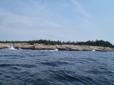 |
| Rough Waters and Currents at Schoodic Point |
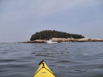
After getting around Schoodic Point, I entered a relatively lonely section of the Maine Island Trail- Downeast. This is a pretty ambiguous term used to describe the northeastern section of the coast of Maine and if you ask 12 different Mainers where downeast begins, you would get 12 different answers. Despite its indefinite borders, Downeast Maine is well regarded as an enchanting and glorious stretch of coast which is often seen in pictures but rarely traveled. By boat or by car, it’s hard to get to.
As I ate lunch on one of the hundreds of uninhabited islands, I had a peculiar sense of loneliness. I had been alone up to this point, but I always seemed to be just close enough to a small port or a group of lobstermen which was comforting. Past Schoodic Point, even the lobster boats thinned out and I made many of my longer crossings alone. The weather was hazy today and although it did not inhibit travel, most of the views were obscured and it amplified the loneliness.
 |
| Near Corea, Maine |
Loneliness on long trips in not entirely unexpected but it comes on abruptly. I value the solitude of such trips but I know at some point I will probably experience times when I wish I had company. It is tough to adapt to and it makes the miles drag on. I briefly stopped in Corea but this was hardly the size of Bar Harbor, Stoningon or Camden. I continued on to round Petit Manan Point.
Petit Manan is similar to Schoodic Point but the reef extends extremely far out off the coast. The reef is so extensive that the Petit Manan Lighthouse is located over 2 miles off shore on a small island. On a kayak it wasn’t necessary to go that far off shore but I had to keep a good eye out for those submerged rocks. Speedy and confusing currents made for slow going and constant heading adjustments.
 |
| Lonely islands |
 |
| I saw fewer lobster boats the further I went |
On the far side of Petit Manan, I encountered another large, lonely bay. I planned on staying on the gigantic Bois Bubert island which is under the jurisdiction of the National Wildlife Refuge. I had called them earlier for permission to stay on the island. Of course, I hit the island at the worst time- low tide and with about 2 hours of daylight left. It was an awkward position because I didn’t happen to find any suitable campsites and I didn’t want to waste precious daylight.
With nearly six days of kayaking under my belt I'm beginning to feel fatigued and worn. I can't say I enjoyed this day as much as the others although I was satisfied with the progress. I covered another 5 or 6 miles from Bois Bubert island and found another wildlife refuge island I could stay on. I had a gorgeous view of a sunset.
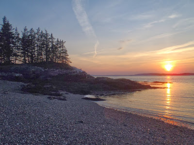 |
| No shortage of gorgeous sunsets and sunrises |
For whatever reason, I've noticed that any pangs of loneliness that I have during the afternoon tend to disappear after sunset. I don't really know why but once night fell, I was in cheerful spirits once again. I had a belly full of canned chili and was stargazing from the safety of my tent. I read books, studied charts and enjoyed my temporary home.
Veritable swarms of mosquitoes covered my tent, poised for an all out ambush should my bladder force me out of my refuge. For all the natural glory that is Downeast Maine, I've never, ever seen more mosquitoes in any place on this continent. This includes other places famous for mosquitoes- Alaska, northern Minnesota, Michigan's Upper Peninsula, Ontario, central New Brunswick... Downeast reigned supreme. I was the only inhabitant of this island so by my estimates, there were about one hundred million mosquitoes per capita. I was probably the only meal they had in weeks.
All things considered, it had been a good day; I safely rounded two of the most exposed points on the coast and covered an additional 28 miles. I was nearing the end of this adventure.
Next: Jonesport to Machias and finishing the Maine Island Trail


No Comments