Like the last two hikes, the Brothers Loop is a favorite of many Baxter State Park hikers. This is a challenging hike which encompasses North Brother, South Brother and Mt Coe with the option of hiking Fort Mountain. North Brother is of interest because it is a 4,000-footer while Coe and South Brother are merely great lookouts (and also on the 100-highest list). Fort Mountain is of interest for a few strange reasons- one that it is a tough bushwack on the 100 Highest list but more commonly it is hiked to see the wreckage of a B-54 bomber which tragically
. As for me, I was simply hiking it for the 100-highest status.
The Brothers loop will definitely take you all day but there are some fantastic summits along the way-
This is one of those hikes where you need a particularly early start. It would be best to either camp in the park overnight or get to the park gate when it opens at 6AM. It takes about 45 minutes to reach the parking lot from the gate. Use the map above to get directions.
The first 1.1 miles to the junction are pleasantly steep. At the junction, you can either head right and tackle the infamous Mt Coe slide first or head left and climb North Brother first. Either way, its a flatter ascent at first followed by a murderously steep section. I elected to head up North Brother first so that if afternoon thunderstorms came in, I would be off its bare summit by then. It is 2.0 miles from this junction to the saddle between North and South Brother. The trail is very well marked and open.
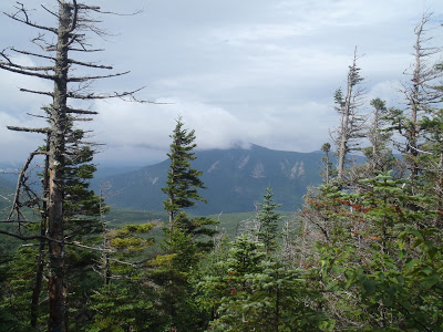 |
| Nice view of Doubletop Mtn from the brothers trail |
At this saddle, turning left will bring you to the 4,151ft summit of North Brother while going right will bring you to the turnoff for South Brother. I headed up North which is 0.7 miles according to the National Geographic Map. (There are discrepancies between different maps and the trail signs). The trail up North Brother was a little dicey in some sections- overgrown and wet. Although it was easy to follow, it felt rather unmaintained. Eventually I popped out on the completely foggy and bare summit. Oh well...
I should note that the view on top of North Brother is usually amazing and later that day when I had clear weather, I could tell you could see most of the park from the summit. Alas, that's just another reason why I will have to come back some day.
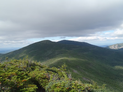
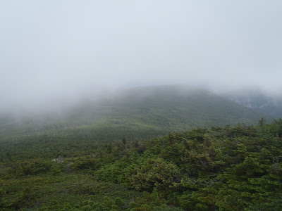 |
| Looking off towards Fort Mountain from North Brother |
Now, as I said earlier, I wanted to hike Fort Mountain as well. For those who have any reason to hike Fort Mountain, be warned; its a hell of a bushwack/heard path. The trail leaves directly from the North Brother summit and is almost a straight shot over the saddle and to the summit of Fort. I would NOT recommend you bring some big trail backpack on the way- you will be fighting a battle against thick krummholz and underbrush. The route is well marked with tape and a few cairns but make no mistake; it would be easy to get lost between the summits.
Damn that was a struggle! I know that many have been on worse bushwacks than this and in the way of New England bushwacks, this one's nothing. The fact that there is at least a somewhat clear route with tape makes it easier... but by the time I was on the summit of Fort Mountain, I was sliced, diced and not feeling to happy about this decision. There wasn't even a view in the fog. Why do I do these things?
Ah well... all part of the New England hiking experience. I made my way back through the bush and popped back out on the summit of North Brother. I couldn't believe that the total round-trip distance to Fort and back was 1.2 miles. Bummah!
 |
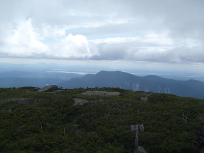
| The summit of South Brother |
After getting down from North Brother, I was back at the saddle and started making my way to the summit of South Brother. It was a comparatively nice walk. There is a turn-off to to the summit just 0.6 miles past the saddle. Its 0.3 miles up to the summit of South Brother. While North's view eluded me that day, South was completely clear and I got was I came for!
The weather was finally moving out, as predicted that day. The hike instantly turned from misery to magnificence. One should always expect rough weather when hiking in Maine which makes good weather all the more enjoyable. I actually spent some considerable time on the summit which is also rare in New England as I usually get chased off by fierce winds or a threatening thunderstorm.
 |
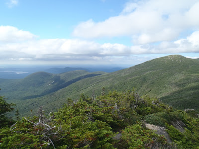
| Doubletop Mountain from South Brother |
 |
| Clear weather on the brothers loop |
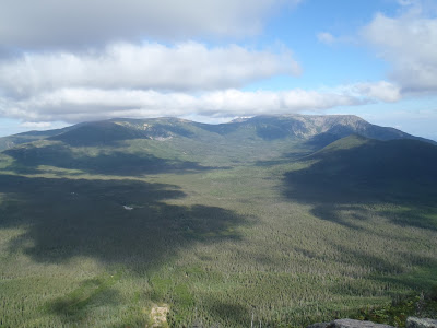
 |
| View of the Brothers from Mt Coe |
From the turnoff of South Brother, it was about another mile to the summit of Mt Coe. Again, another gorgeous summit. Mt Coe is the shortest of the summits on this loop but the views of the Klondike basin and Mt Katahdin were phenomenal. Thank goodness!
Although the ascent up to the Brothers saddle had been crazy as well as the up and down and up and down of North Brother and Fort Mountain... my biggest challenged lied ahead- the Mt Coe slide. There's really no nice nor easy way to go up or down Mt Coe. The slide is exposed, steep, slippery and rocky. It is reminiscent of the slides on the Tripyramids in New Hampshire if you've ever done them. Going up it is tough but coming down it is tougher. There were just too many opportunities to lose one's footing and slide down 500 feet of scree. I would say this was the least enjoyable part of the day. You've been warned!
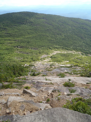 |
| Might not look too bad from this picture... but it was a heck of a way to get down |
After coming down from the slide, it was a gentle descent of about 1.1 miles back to the turnoff for North Brother. Then its another 1.1 miles back to the trailhead. I left at about 0700 and was back by about 1700. It was a long but accomplished day.
According to my map, the distance was about 11 miles which includes the crazy jaunt over to Fort Mountain. Without that, its about 9.5 miles, I believe but other sources and other maps may differ. Regardless, it is a full day's hike and there's enough ascents and descents to make it a challenge for anyone. The fun's not done; I camped out at Nesowadnehunk Field and was off to the summit of Doubletop the next day. Boy did I rest well that night though!
Read. Plan. Get Out There!


No Comments