Sunrise Coast. Lobster Coast. Bold Coast. Downeast. Acadia. Although it stretches only 230 miles from New Hampshire to New Brunswick, this distance includes Maine's 3,500 miles of jagged coastline and 3,000 islands surrounded by vicious tides and currents. Capturing the imagination of natives, explorers, artists and poets across the centuries, the coast of Maine has become the symbol of the state.
Knowing how central Maine's coast was to its history, economy, art and literature, it was just fitting to me that I would one day head off and see the whole coast for myself. As it turns out, somebody thought of this long before I did. Twenty-five years ago, about the time I was born, the Maine Island Trail was forged for the purposes of exploration and recreation. Now there were over 200 campsites stretching from Portsmouth Bay to Lubec and the Canadian Maratimes. With a robust group of volunteers and a dedication to the wilderness similar to the Appalachian Mountain Club, the Maine Island Trail is the nautical answer to the Appalachian Trail. It would be perfectly reasonable to set forth on the Maine Island Trail and travel 2,100 miles without seeing the same thing twice.
 |
| Maine's most classic adventure |
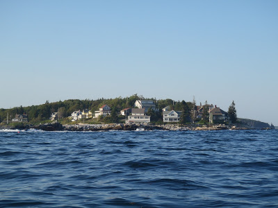
In a coastal trip from New Hampshire to Canada you would see nearly everything that makes this area so vital to Maine. The comparatively gentle southern beaches of York, Kennebunk and Old Orchard Beach showcase Maine's softer shores and beckon leisurely paces and hours spent on quiet New England beaches. Rounding Cape Elizabeth gives the kayaker unobstructed views of Maine's famous lighthouses. The extensive Casco Bay holds the largest harbor in the state and a enough historical forts to prove Maine's critical roll in the Revolutionary War and the War of 1812. Massive cruise ships and tankers race in and out of the bay alongside yachts circumnavigating the globe. No trip around the Atlantic would be complete without seeing the Lobster Coast.
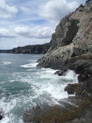 |
| The bold coast |
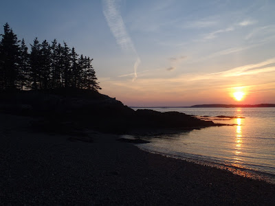
Moving northeast, Maine's largest rivers finally make it to the sea. The Kennebec, Androscoggin and Penobscot rivers make their way from high in the White Mountains and Appalachians of Maine and enter the ocean with terrific force. Fertile lobster grounds are covered with trap buoys and lobster boats become close companions. Further up the coast is Penobscot Bay which forms a large bight and half a dozen friendly island towns. Finally there is Acadia and downeast Maine whose shores and mountains have inspired art across the world. Perhaps half of the art in the Portland Art Museum was inspired by this coast. Dependable winds and favorable currents push the mariner further and further away from civilization and eventually to end of Maine or the beginning of the country.
At no point does the trip become predictable. At every point the mariner is exactly halfway between peril and paradise. The same forces which form the stunning cliffs of Acadia could easily be the demise of a careless mariner.
 |
| Easy to lose one's way on the "drowned coast" |
I have to do it now. Voyaging in a boat up the coast would be the original Maine Adventure. So I took two weeks off from work, spent a thousand dollars on a touring kayak, bought two-hundred dollars worth of nautical charts and planned my adventure.


No Comments