Baxter State Park is, without a doubt, the crown jewel of Maine's protected lands. It is larger than many national parks and vast as any. Baxter SP is also fiercely preserved in its original state with the strictest protections against any and all development save for dirt roads and primitive campsites. I spent 4 days in Baxter and hike some of its finest.
 |
| Baxter State Park Wilderness |
One of the first things I did when I came to Maine was climb Mt Katahdin in Baxter State Park. Why not though- its the highest mountain in Maine and in the middle of a vast alpine wilderness. The trip was wonderful, of course, but I was surprised at how large Baxter State Park really is. Before getting the map, I just assumed Baxter was essentially just a park for Mt Katahdin. However the Katahdin massif is less than 1/8th of the size of the park and there are some 60 other summits that can be hiked. Well I would just have to see some of those!
Baxter State Park is an anomaly among publicly preserved lands. Donated by one of Maine's most famed politicians, Percival P. Baxter, and is neither a true state park nor a national park. Instead it is a land trust that is open to the public and free to Maine residents. So I hit the road again, ready to explore the lesser known parts of our wonderful wilderness! Day one would be a hike up "The Traveler"
The Traveler is a unique hike for many reasons. Primarily, it is because the red volcanic rock which is not often found in Maine or New England. The Traveler is, in fact, Maine's largest volcanic formation which is of interest to both geologists and hikers. For hikers in particular, it means that almost the entire 10 miles of the hike is exposed and above treeline. I don't think I've ever had such extensive views for this long of a hike. Katahdin has extensive views too, but the entire first half of the hike is below treeline. Bottom line, after hiking nearly every mountain with a trail in Baxter, I chose Traveler as the best.
Getting to Baxter State Park is not easy from anywhere. Getting to the North End of Baxter is even more difficult. This is good news to folks like me who prefer a lonely trail to a crowded one. You can use the map above for directions but expect there to be not very many services once you get off the 95 freeway and the classic BSP dirt roads once you get into the park. Nevertheless, it was accessible to me and my lil sedan- no 350 4x4 required to see this one.
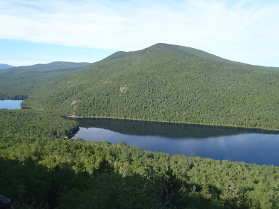 |
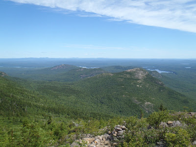
| View of the south ponds from the Traveler hike |
 |
| Volcanic rocks on the route up Traveler |
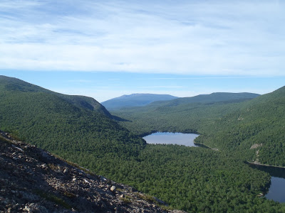 |
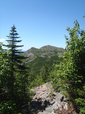
| View of Mt Katahdin from Traveler hike |
If you can stand the distance, the Traveler loop is really one of Baxter State Park's best hikes. It is 10.5 miles and has significant elevation changes. But you may hardly notice the steepness of the hike when you have panoramic views along most of the trail. Even the forested parts of the trail are pretty. Within 0.5 miles of starting the hike, I was greeted with views of Katahdin and Black Cat mountains and the volcanic rocks which make up the Traveler. It didn't take more than 2 hours to get to the summit of North Traveler which was completely open. On a hot day this hike might be insufferable, but with the temperatures hovering in the 60s and the sun out, it was pleasant. From North Traveler, you could turn around if you're worried about time or distance but the views only get better from here.
The trail dips below the summit and crosses the saddle between North Traveler and the Traveler where there are bits of shade. As you can see from the map, there are many ups-and-downs but again, the trail is just too pretty to notice these things.
 |
| Mountains, lakes, forests, Maine |
 |
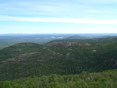
| Peak of the Ridges serves as the third and final summit of the trip |
 |
| Numerous summits come into view on the top of the Traveler |
The summit of the Traveler serves as a rough half-way point of the hike but there is one other summit on the way down to the trailhead. Peak of the Ridges is another bare summit with views of the entire valley created by the three peaks. Its a bit of a scramble in some places, but the trail is well marked and easy to follow.
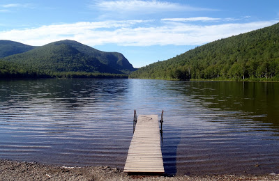
Coming down from Peak of the Ridges is especially steep in some places and is a great example of why I always bring trekking poles. At some points it was so steep and rugged that it felt like a climb down. Be prepared for this if you have shoddy joints. However the trail dumps you out right near the ponds which is an excellent place to cool down or take a swim. From the ponds, its a short walk back to the trailhead.
Well it could have been the uncommonly agreeable weather, but the Traveler has to be one of my favorite hikes in Maine. I'm sure I say that all to often, but it was certainly unique to climb a large volcano in this part of the country. I would go so far to say that if I had to chose between bagging Katahdin or Traveler again, I would go with Traveler. Nevertheless, tomorrow I would be headed out to climb Hamlin Peak on the same ridgeline.
Read. Plan. Get Out There!


3 Comments
Tim
August 1, 2013 @ 23:09
Hi, I just returned from Baxter, I go annualy every third weekend in July. Did Katahdin via Chimney and Cathedral… bouldering adventure!
Also did North and South Brother as well as Coe and OJI all in the same 13mi loop… beware, Marston trail is great, but OJI link from Coe has two steep rock slides (of course it was raining!) And is very undeveloped… not a soul around!
Im planning on Doubletop next year, but your hike looks fantastic… hmmmm 🙂
Quincy Koetz
August 4, 2013 @ 22:49
Doubletop was every bit as good as Traveler. I actually hiked that one too and will be writing about it shortly! Thanks!
Aaron Pudlo
September 10, 2013 @ 03:06
Just did this trip on Saturday 9-7-13 in a Counterclockwise Loop, what a great hike! The middle section of this Loop is a new trail so very few people have had the chance to experience what you wrote about here Joe…BTW went for a beautiful (albeit chilly) swim in Lower South Branch Pond to finish our hike, truly a perfect ending to the perfect day!