


Mt Carleton is the highest mountain in the Maritime Provinces of Canada (New Brunswick, Prince Edward Island and Nova Scotia). The International Appalachian Trail crosses over the summit and nearby two other spectacular views along the way.
Previous: Hiking Mars Hill, Maine.
After hiking Mars Hill, I crossed the international border at Van Buren and headed across New Brunswick to Mt Carleton Provincial Park. This park is of interest to me because Mt Carleton is both a prominent summit in the Canadian Appalachians and it is also part of the International Appalachian Trail. From the summit, one can see great swaths of mountains, rivers and lakes from its comparatively modest elevation. Whether or not the International Appalachian Trail interests you, it is an excellent hike and often done by Canadians and Americans alike.
Mt Carleton Provincial Park is somewhat off the beaten path, even for New Brunswick, but the park itself is well preserved and maintained. Here is a hiking map-
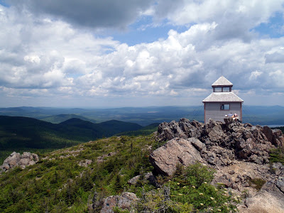 |
| The famous lookout tower on the summit of Mt Carleton, New Brunswick |
After hiking Mars Hill, I crossed the international border at Van Buren and headed across New Brunswick to Mt Carleton Provincial Park. This park is of interest to me because Mt Carleton is both a prominent summit in the Canadian Appalachians and it is also part of the International Appalachian Trail. From the summit, one can see great swaths of mountains, rivers and lakes from its comparatively modest elevation. Whether or not the International Appalachian Trail interests you, it is an excellent hike and often done by Canadians and Americans alike.
Mt Carleton Provincial Park is somewhat off the beaten path, even for New Brunswick, but the park itself is well preserved and maintained. Here is a hiking map-
View Hiking Mt Carleton Provincial Park in a larger map
The visitors center provided me with excellent directions and a map of all the hiking trails. It was pretty cheap admission too. From the entrance of the park, it didn't take longer than 20 minutes to get to the trailhead. (Just use the parking lot marked above to get directions through Google maps). There are six different ways to hike Mt Carleton but the route above is the most commonly hiked route.
From the Mt Carleton Parking Lot, you could take a left or a right. The trail to the left is slightly longer- 4.9km, one way to the summit and there is a backcountry campsite along the way if you want to stay overnight. The trail to the right is a shorter hike- 3.4km, one way to the summit but it is steeper in some sections. Either way, you will eventually reach the summit of Mt Carleton.
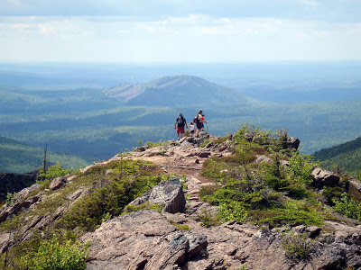 |
| Hikers on the summit of Mt Carleton |
The trail to the summit is easily followed in French or English and doesn't take more than 2.5 hours, one way. The summit is bare and has views in every direction. It is one of the best views in all of New Brunswick! There were many other hikers at the summit enjoying this quintessential adventure.
Many hikers chose to continue hiking past Mt Carleton and hike Mt Head and Mt Sagamook which also have great views. Although not quite as magnificent as Mt Carleton, the hike to Mt Head and Sagamook does make for a nice, all-day hike. Its much flatter than the trail up Mt Carleton so it doesn't take too long. From Mt Carleton to Mt Head, its 3.0km, one-way. From Mt Head to Sagamook, it is an additional 1.8km, one way. This makes the whole trip 16.4km round trip from the Mt Carleton Parking lot. This is 10.2 miles, total distance.
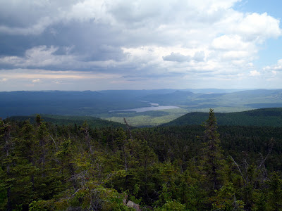
 |
| View of Lac Nepisguit from the summit of Mt Carleton |
 |
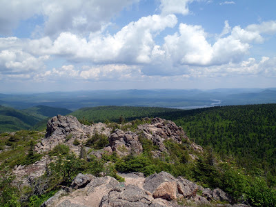
| View to Mt Head and Mt Sagamook, from Mt Carleton |
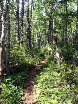 |
| Hiking through the woods in Mt Carleton Provincial Park |
 |
| View from Mt Head, New Brunswick |
The hike along the Mt Carleton trails ended up being a full day hike and I wish I could have hiked in the other areas of the park. Its actually a dark sky preserve too which means it has uninterrupted night sky views. It was cloudy that night so I could not enjoy this aspect of the park but that would have added to the experience. Dark Sky preserves are few and far between.
Both the Nictau Lakes and Nepisguit Lakes also have hiking trails which are more tame that the ascent of Mt Carleton. I would have likes to stroll along these areas as well. Mt Carleton Provincial Park felt more like a National Park than anything!
From here, the International Appalachian Trail continues through the lower mountains of New Brunswick until reaching the Madapedia River and crossing into Quebec and the Chic Choc Mountains. This was where I was headed next!
Next: Hiking Mt Albert, Gaspe National Park, Quebec.
Next: Hiking Mt Albert, Gaspe National Park, Quebec.
Read. Plan. Get Out There!

1 Comment
gary w
August 1, 2022 @ 20:24
very nice, thanks for posting