


Several years ago, I was able to take one of the best adventures of my life with Camp Emerald Bay when I kayaked around Catalina Island. I like the trip so much that I did it again a few years later when we did a canoe circumnavigation of the island. Catalina Island is a kayaking and canoeing paradise!
Its been a while since I last posted and I don't want it to look like I've forgotten about my website! This semester of grad school has been quite the ride and I've been working a new job at the hospital which has made it difficult to get out there lately. However summer is coming and you'd better believe that its going to be a whole new round of grand adventures and blog posts about places you've never heard of (I'm a hipster traveler). This is a post that has been several years in the making.
Catalina Island is really where I first learned to kayak and its also where I first started going on multi-day kayaking excursions. Kayaking and canoeing around the island has been one of the best experiences of my life and after 6 summers of working out at a Boy Scout camp on the island, I became very familiar with how to kayak Catalina.
I've circumnavigated Catalina Island once by canoe and once by kayak and it is a daunting affair any way you slice it. On the mainland-facing side of the island, campsites tend to be close together and there are many options for landings. The ocean-facing side of the island is much more rugged and is marked by towering cliffs, massive currents and few options for landings. This is to say, once you cross around the East or West End to the far side of the island, you are entering an area of extreme remoteness and better know what you're doing.
What to See!
I've kayaked Maine, Minnesota, Alaska, New Brunswick and part of the Colorado River and I still think Catalina is one of the most fantastic places for paddling. The mixture of thousand-foot cliffs, secluded beaches, kelp forests and wildlife make it a unique trip. Its only 20 miles off the coast of Southern California but its a world away.
Assuming you head in a Northwesterly direction out of Avalon, the first leg from Avalon to Two Harbors hugs the land-facing side of Catalina and you pass by many established camps and primitive sites. Canyons predominate this leg and it seems like every canyon has a small settlement tucked away by steep walls. As you round the light on Long Point, there is a sea arch that is curiously shaped like the outline of Catalina Island. From here, there begins a series of remote boat-in campsites which must be rented from the Catalina Island Company. They do not have any amenities and you will have to pack in your own water and food. Nevertheless, there are some particularly beautiful sites such as Italian Gardens, Cabrillo Harbor and Lava Wall Beach.
After these sites, you continue in a more westerly direction past the old quarry and into Two Harbors. Just before entering the Harbor, there are massive sea caves which can't be missed along Blue Cavern Point. If the tides are right, you can canoe through the cave. Bird Rock and Ship Rock are clearly visible from the harbor as well. Campsites abound.
From Two Harbors you begin the arduous journey around the West End of Catalina Island which is marked by significant currents, waves and surf. Arrow Point, the northernmost part of the island is particularly hazardous. However you are rewarded with incredible sites of the underpopulated part of the island. Parson's Landing is a fantastic campground with plenty of options. The next available campground is Starlight Beach which is remote and difficult to find if you haven't boated in to it before. It is just before the tip of the West End.
Coming around the West End of Catalina Island will undoubtably be one of your greatest challenges. It is exposed to many currents and submerged rocks. Its best to give the West End much leeway. Its also best to camp out at Starlight or Parson's Beach the night before and hit this tricky section in the early, early morning when weather and currents are light. However you will have stunning views of the Bald Eagle Reservation and Eagle Rock (pictured above)
The backside of the West End is nothing but cliffs. Its a good 10 miles too- best not to end up on the far side of the island when the wind and currents are bad. Radio transmissions become difficult. But the 1,000 foot cliffs and Ribbon Rock will keep your mind off the any headwind you might be paddling in to!
Its possible to land in Catalina Harbor on the opposite side of the Isthmus. Here you can get back to Two Harbors village but there are no particular campsites in Cat Harbor. The next available campsite is Little Harbor which is several miles further. Little Harbor also has many campsites but paddling into the cove can be difficult as the waves can pick up.
After leaving Little Harbor, you once again enter an oceanic wilderness as you round the widest section of the island and come around the rugged, southern part of the island. There are no roads, campsites and only one landing at Silver Canyon. It is, without a doubt, the farthest you will be from others on your trip. But the waters are crystal green and the cliffs are imposing. I always looked forward to this part of the journey where you feel like an ancient explorer or Catalina native. Its so far from anything and there is nothing save for what's in your kayak or canoe to remind you of what century your in.
 |
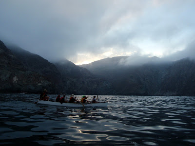
| Kayaking Catalina Island at Camp Emerald Bay |
 |
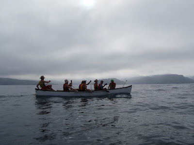
| Canoeing Catalina Island |
Catalina Island is really where I first learned to kayak and its also where I first started going on multi-day kayaking excursions. Kayaking and canoeing around the island has been one of the best experiences of my life and after 6 summers of working out at a Boy Scout camp on the island, I became very familiar with how to kayak Catalina.
 |
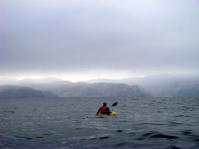
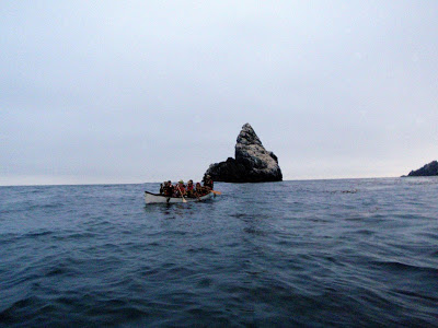
| Kayaking the remote cliffs of the far side of Catalina Island |
Hopefully this map will clarify what I'm saying
View Kayaking Circumnavigation of Catalina Island in a larger map
It can be anywhere from 52 to 66 miles to circumnavigate the island depending on how closely you hug the shoreline and how many coves you cross. While it looks tempting to make some of the longer crossings over open water to cut off mileage, the currents and surf can get especially strong the further you get away from the island.
Getting you and your kayak to Catalina Island
Its quite expensive to get to Catalina Island from Los Angeles, unfortunately. The Catalina Express makes multiple runs out of Two Harbors and Avalon every day and the round trip ticket price is 72.50 (when I was your age, you could get there and back for $55!). I've never tried, but I am sure there's an extra surcharge for bringing your kayak on board as well. If you don't have your own kayak, it is possible to rent them on the island but I would recommend against it because the prices are very expensive and you won't get a touring kayak. You NEED a touring kayak to circumnavigate the island. A sit-on-top kayak will NOT handle well in difficult surf and currents. My recommendation is, if you can, rent a kayak on the mainland and bring it over yourself. You will get a cheaper deal on a better kayak.
 |
| Open water kayaking, south side of Catalina Island |
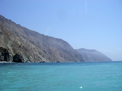 |
| Crystal Green Waters on the South Side of the Island |
I've kayaked Maine, Minnesota, Alaska, New Brunswick and part of the Colorado River and I still think Catalina is one of the most fantastic places for paddling. The mixture of thousand-foot cliffs, secluded beaches, kelp forests and wildlife make it a unique trip. Its only 20 miles off the coast of Southern California but its a world away.
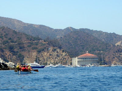 |
| Canoeing into Avalon Harbor, Catalina Island |
After these sites, you continue in a more westerly direction past the old quarry and into Two Harbors. Just before entering the Harbor, there are massive sea caves which can't be missed along Blue Cavern Point. If the tides are right, you can canoe through the cave. Bird Rock and Ship Rock are clearly visible from the harbor as well. Campsites abound.
From Two Harbors you begin the arduous journey around the West End of Catalina Island which is marked by significant currents, waves and surf. Arrow Point, the northernmost part of the island is particularly hazardous. However you are rewarded with incredible sites of the underpopulated part of the island. Parson's Landing is a fantastic campground with plenty of options. The next available campground is Starlight Beach which is remote and difficult to find if you haven't boated in to it before. It is just before the tip of the West End.
 |
| Rounding the West End, Catalina Island |
The backside of the West End is nothing but cliffs. Its a good 10 miles too- best not to end up on the far side of the island when the wind and currents are bad. Radio transmissions become difficult. But the 1,000 foot cliffs and Ribbon Rock will keep your mind off the any headwind you might be paddling in to!
Its possible to land in Catalina Harbor on the opposite side of the Isthmus. Here you can get back to Two Harbors village but there are no particular campsites in Cat Harbor. The next available campsite is Little Harbor which is several miles further. Little Harbor also has many campsites but paddling into the cove can be difficult as the waves can pick up.
 |
| Paddling by Little Harbor |
Silver Canyon is a feasible landing and it is possible to camp here if need be. Past this are the Palisades and the East End. Sea Lions love this area and every small beach and rock is covered in sea lions. You'll be able to hear their noisy conversations as you round the East End and head back to Avalon.
Its somewhat sad to leave the far side of the island behind with all its splendor and majesty. At this point you may be thirsty for a margarita or pina colata and a hot meal, but there's no doubt you'll feel a twinge of regret leaving the wilderness behind.
Counter-Clockwise Circumnavigation Route
Circumnavigating the island is more than just making a big circle; there's some important logistics that go into planning this trip. Winds and currents can be unpredictable, but for the most part, they come from the West which is why most trips I've ever taken were in a counter-clockwise direction. It's better to have the wind and currents with you as you travel east along the backside of the island where you have little options for campsites and landings. When you're paddling into the headwind on the land-facing side of the island, there are more options for campsites and landings should you get into trouble. Having said that, I've had trips where the winds and currents completely switch day by day.
The route you take will determine how much wind and currents you will deal with along with how many miles you travel. Catalina Island has about 54 miles of shoreline with many inlets and secluding coves. Its a figure-8 shape which makes for an interesting route. Its tempting to want to cut off some mileage on the ocean-facing side of the island but that exposes you to more currents and surf. If the conditions are right and you're comfortable being 2-3 miles off shore, its can sometimes be worth the trouble. Hopefully this map will put it into perspective.
 |
| Silver Canyon and the Palisades, Catalina Island |
 |
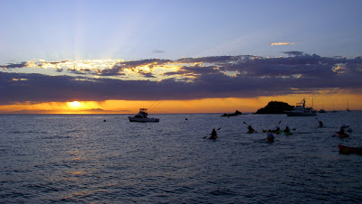
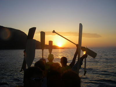
| Sunset on Catalina Island |
Counter-Clockwise Circumnavigation Route
Circumnavigating the island is more than just making a big circle; there's some important logistics that go into planning this trip. Winds and currents can be unpredictable, but for the most part, they come from the West which is why most trips I've ever taken were in a counter-clockwise direction. It's better to have the wind and currents with you as you travel east along the backside of the island where you have little options for campsites and landings. When you're paddling into the headwind on the land-facing side of the island, there are more options for campsites and landings should you get into trouble. Having said that, I've had trips where the winds and currents completely switch day by day.
The route you take will determine how much wind and currents you will deal with along with how many miles you travel. Catalina Island has about 54 miles of shoreline with many inlets and secluding coves. Its a figure-8 shape which makes for an interesting route. Its tempting to want to cut off some mileage on the ocean-facing side of the island but that exposes you to more currents and surf. If the conditions are right and you're comfortable being 2-3 miles off shore, its can sometimes be worth the trouble. Hopefully this map will put it into perspective.
View Circumnavigation of Catalina Island- Cutting off the Isthmus Bight in a larger map
Other Logistics: Water, Food, Camping ect.
Its important to note that Catalina Island is essentially a desert and although the marine layer moves in and out every morning, it rarely rains and there are no real water sources along the trip. Two Harbors, Avalon and Little Harbor have water available as well as firewood. Parson's Landing also has firewood and water available but make sure you reserve the campsite. Its also possible to buy food at Two Harbors and Avalon.
If it hasn't been said yet, just know that there are no services available on the ocean-facing side of the island save for the long paddle into Catalina Harbor and Little Harbor. Otherwise, you're on your own.
Its a heck of an adventure to circumnavigate the island or even just to go out for a couple of days afloat. Any trip requires careful planning, good orientation and mapping skills. Get yourself well trained in kayaking or canoeing before you go too. Also, don't forget, there are other Channel Islands to paddle as well!
Read. Plan. Get Out There!
Its important to note that Catalina Island is essentially a desert and although the marine layer moves in and out every morning, it rarely rains and there are no real water sources along the trip. Two Harbors, Avalon and Little Harbor have water available as well as firewood. Parson's Landing also has firewood and water available but make sure you reserve the campsite. Its also possible to buy food at Two Harbors and Avalon.
If it hasn't been said yet, just know that there are no services available on the ocean-facing side of the island save for the long paddle into Catalina Harbor and Little Harbor. Otherwise, you're on your own.
 |
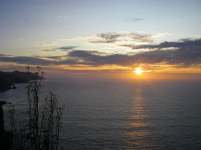
| Catalina Sunset |
Read. Plan. Get Out There!

7 Comments
Mike
October 5, 2021 @ 21:31
I have been looking into this trip myself via kayak. How can you book a remote campsite on the remote side of the island? All the research I have done, it seems illegal to camp on the far side other than
Quincy Koetz
October 8, 2021 @ 15:52
The backside is very tricky and things may have changed since I last did a circumnavigation. Going counter-clockwise, you could camp in Two Harbors, 1/2 day or so to Starlight beach, long day rounding the West End to Catalina Harbor or Little Harbor. From Little Harbor, there’s really not much although Silver Canyon landing looks very camp-able; would have to check with Catalina Island Company if they allow that anymore. Could do an extremely long day from Little Harbor to Avalon; with a super early start and favorable weather it is do-able. But as far as established campgrounds, its basically Catalina Harbor/Two Harbors and Little Harbor on the backside. Hope it works out!
-Quincy
Jen Bacani
October 12, 2021 @ 18:58
Thanks for this. About how many miles and hours a day would you say you traveled via kayak? My friend and I are looking to do Two Harbors to Avalon spread out over three days. I think this is too short though averaging just a few miles a day. How many lbs would you say you had on your kayak with overnight gear? Do you know if the same rental company has a pickup in Avalaon and drop off in Two Harbors or vis versa? I haven’t done too much research yet, your post was the first I stumbled on!
Quincy Koetz
October 15, 2021 @ 17:50
Its a great trip going from Avalon to Two Harbors! If the currents are good its actually reasonable to make that trek in a day depending on how long you want to paddle. Two days would be pretty leisurely paddling I’d say (depending on weather and time of year. There’s a lot of boat-in campsites along the way which makes it pretty do-able. I recall having a pretty loaded kayak for all those trips- there’s no water at any of the campsites so I recall bringing a gallon per person, per day if that gives you an idea of gear. I don’t know if a rental company would pick you up in Two Harbors but I remember people bringing kayaks aboard the passenger boat between two harbors and avalon pretty regularly.
Gurpreet Singh
June 16, 2022 @ 00:31
I am thinking about doing this trip counterclockwise and wondering what time in the year m would be the best. Any recommendation?
Thanks
Gurpreet
John
October 1, 2022 @ 01:18
That sounds awsome. I’ve hiked the transCatalina trail but would love to canoe or kayak it. Could you share how you got your canoe/kayak there?
Quincy Koetz
October 6, 2022 @ 04:16
I happened to be working at a camp there and was able to have one of their canoes for the week. I think the best bet would be to rent a kayak on the mainland and bring it over on the Catalina Express. Catalina kayak rentals from the island tend to be expensive and rented by the hour. Hope that helps!