


You may have thought I would have rested my laurels on the accomplishment of hiking Rhode Island's highest mountain. However as soon as my body recovered from that deadly ascent, I crossed the border and headed off to Mt Frissell, Connecticut... well actually it is in Massachusetts...
 |
| Hiking Mt Frissell, Connecticut |
New England has a mixed bag of high points; some are challenges, some are pretty, some are strange and well... others aren't even really mountains. Mt Frissell is definitely a mountain, but the summit is in Massachusetts. Hence, the highest point in Connecticut isn't exactly a mountain but more a part of a mountain. So Connecticut falls under the same curse as Nevada and Maryland who also have substantial mountains but the highest "point" happens to be part of another mountain in another state. Nevertheless, they must still be climbed...
While Rhode Island's Jerimoth Hill was a whimsical little hike with a dubious history, Mt Frissell was an actual hike and it was in a beautiful part of the Taconic Mountains. Located in the northwestern corner of the state, it is actually accessed from Massachusetts.
View Hiking Mt Frissell, Connecticut in a larger map
So the trail up to the summit is located on the border of Connecticut and Massachusetts and I ended up driving in from the North. Its on somewhat of a high plateau and you're taking country roads and dirt roads to get there. Not that its difficult to get to, but it is off the beaten path and you won't see any signs for it along the way. I ended up taking the Mt Washington Road out of Egremont Massachusetts which heads south up the large plateau and into the mountains. Again, its a bit of a backroad but it's paved for most of the way until the last 5 miles. Just keep driving south on Mt Washington Road until you get to the dirt road part of it and keep going until you see the MA-CT border marker on the left. The parking lot is just across the border and it is marked as Appalachian Trail parking lot. The trailhead is just back on the Massachusetts side and heads west into the mountains.
From here, the trail meanders through the woods and climbs a steep promontory which is NOT the summit. It looks like it would make for a great high point, however the destination is still west of this point. However there are excellent views of the Taconics, Berkshires and most of rural Connecticut from this point. Actually, its the best view you will get on the hike!
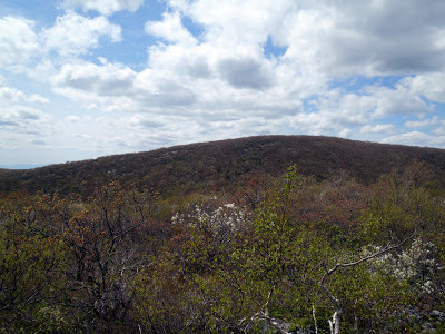 |
| The summit of Mt Frissell, Connecticut and Massachusetts |
From here, the trail heads down to the saddle between the two mountains and races back up to the true summit. At the top, there's a register and a little map showing where to go. It almost looks as if the trail continues north but this is not the real trail. Head back south and follow the trail around for about 1,000 yards. Some trees were cut to give you a good view of Connecticut and before you know it, you'll be standing at the high point!
There is a summit marker but nothing too celebratory, unfortunately. The summit register can be signed and its neat to see the other high pointers and how far they have traveled for this peculiar spot on the side of a mountain.
After the CT high point, you can continue on for about another 1500 yards to the Connecticut-New York-Massachusetts triple point where all the borders come together. Its nothing to see but its a quirky little place anyways. There's a marker that denotes the spot but otherwise its indistinguishable from the surrounding land.
Well this was my 14th state high point! I've also done- California, Oregon, Washington, Colorado, Arizona, Nebraska, South Dakota, North Dakota, Rhode Island, Vermont, New Hampshire, Massachusetts and Maine. Not too bad and I have the rest of my life to do silly things such as these!
Read. Plan. Get Out There!
There is a summit marker but nothing too celebratory, unfortunately. The summit register can be signed and its neat to see the other high pointers and how far they have traveled for this peculiar spot on the side of a mountain.
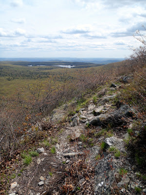 |
| Pretty views along the hike to Connecticut's highest point |
Well this was my 14th state high point! I've also done- California, Oregon, Washington, Colorado, Arizona, Nebraska, South Dakota, North Dakota, Rhode Island, Vermont, New Hampshire, Massachusetts and Maine. Not too bad and I have the rest of my life to do silly things such as these!
Read. Plan. Get Out There!

No Comments