


 |
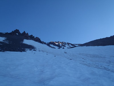
| Excellent Snowcover on the Avalanche Gulch route for this time of year! "The Heart" is the large rock outcropping to the right of the highest point in this picture |
Poor early-winter conditions prevented me from hitting Shasta in 2009 when I happened to be in the area. Again, I wanted to climb Shasta again in 2010 while on a road trip but the mountain conditions were sketchy and a storm prevented me from even getting to the trail. So, finally in 2011, I was going to do this mountain!
 |
| Sunrise on Avalanche Gulch |
Shasta-la-Vista Baby!
The route of choice up Shasta is the Class III Avalanche Gulch Route. Its a relatively easy route up Shasta- just snowfields, easy route finding and no significant glacier travel. This is the route that guided groups usually take and therefore you will always see ill-prepared pseudo-climbers who get turned back early in the climb. Although it has a reputation for being easy, its still a route with 7,000ft of gain and most of it is in thin air! Therefore, it was still a challenge for me!
I hit the trail late again- 4:45AM and I could already see the lights up the mountain of climbers who had bivy-ed just bellow the route and were hoping for a sunrise climb. The trail to the Sierra Club Cabin is a beautiful route through the sub-alpine forest. There are great patches of colorful alpine flowers and a couple views of the Summit. Arriving at the cabin an hour later, it was just barely first light. There is a mountain spring by the cabin that provides pure, cold and glorious mountain filtered water. You could find no purer water on Earth!
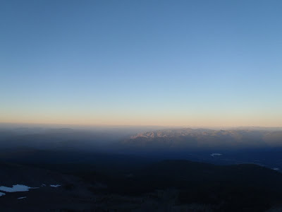 |
| Sunrise on the Castle Craigs! |
After Horse Camp and the Cabin, I was on the "highway" made of rocks which takes you to Helen Lake. This highway was made by the Sierra Club and it a way to prevent erosion as you climb the well-traveled route up Shasta. I quickly ascended out of the trees to the alpine zone and was greeted with a sunrise over the Trinity Alps and the Castle Craigs. What a glorious sunrise that was! I am becoming more fond of Cascade Sunrises- most of the cascades are isolated enough from other mountains that the sunrises are uninhibited and gorgeous.
As I climbed further up to "the Heart" I began to catch up with the tail end of the constant stream of climbers on Avalanche Gulch. It was a pretty clear distinction between those who knew what they were doing and those who were novice climbers. The experienced climbers moved with slow deliberation while the newer climbers moved too quickly and in shorter bursts. Nevertheless, it was nice to see many people enjoying the mountain!
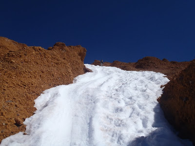 |
| The Red Banks, Mt Shastaa |
Case in point: I was slowly making my way up the Red Banks when I saw a climber trying to glissade down the mountain (A glissade is a half-controled slide down a mountain using the ice axe for a rudder). First of all, this is a highly inappropriate place to glissade because it is steep and crowded. Secondly, if you're going to glissade, you better know how to self-arrest! (self-arrest is how you stop an uncontrolled slide with an ice axe) This one particular climber got on an uncontrolled slide in this very spot and slid 300ft before *somehow* coming to a halt. He wasn't wearing a wrist band to the ice axe so he lost it up the slope. I helped him retrieve his axe, but if you really lost an axe this high... well, you're up sh*t creek without a paddle!
Moral of the story: don't glissade, especially on the steepest part!!
 |
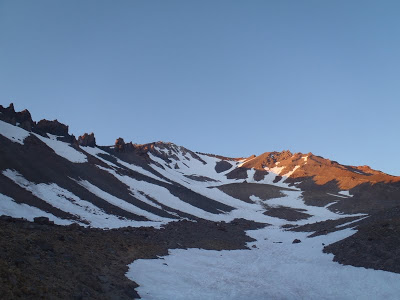
| Misery Hill. The Shasta Summit is 400ft higher than this prominence |
Many climbers think they are almost at the summit when they top out on the Red Banks only to be disheartened by "Misery Hill". This is the last 1,000ft or so to the summit and its actually not too miserable. This time of year you can leave your gear at this little landing and climb the hill in boots. Bring a water bottle and a small snack and you will be good to go.
If you are climbing Misery Hill and there is any threat of storm or cloud cover DO NOT ATTEMPT THE SUMMIT! It is VERY difficult to find your way back down to the Red Banks in shrouded weather and many a climber has gone down the wrong gully thinking its the Red Banks.
Fortunately the weather was wonderful and I slowly made my way to the top. Even with the knowledge that the hill is a false summit, I still thought I was near the top. However there is yet another snowfield and another hill to the true summit. This is near 14,000ft so I was moving as slow as the glacier by the time I summited. The sulpher springs near the top will let you know that you're close
 |
| Snowfield and Summit of Mt Shasta |
Once on top of the summit, I instantly forgot of all the trouble it took to get here! The 360 degree view around the mountain was majestic and it reminded me of how much I missed living in the West. There are no 14ers in the East unfortunantely! There are many grand adventures to be had out in the East and I'm enjoying it. However, the summit of Shasta was enough to make me a little sad that I must spend time away from these lofty mountains. I was able to enjoy the views for the time being and I know I'll return.
 |
| One of many summit views |
I suppose the hardest part about climbing a mountain is desceding. I was down-climbing at about the same rate as I climbed up and the Red Banks were just as slow and steep. However it did provide me with some time to think about this Grand Adventure I've had in Northern California and Central Oregon. I'm glad that I've been able to have some epic adventures back home and also spend some chill time hiking with the family and golfing in Bend. This trip was a healthy balance of relaxation and challenge, which to me, is the perfect vacation.
 |
| So long, West Coast! |
I'll soon be posting some guides on Outdoor Adventures in Bend, Oregon and other trips in the Central Oregon area. Also, now that I'm back on the East Coast, it will be back to summiting all the Mountains in New Hampshire, Maine and Vermont!
Read. Plan. Get Out There!

2 Comments
Matt
December 8, 2019 @ 21:45
Just curious. How dis you get ‘skunked’ at 13000ft (beginning of the headwall) on the Clear Creek Route?
Quincy Koetz
December 26, 2019 @ 05:47
Skunked=turned back in this case. Thankfully was not literally skunked!