


"The tops of mountains are among the unfinished parts of the globe, whither it is a slight insult to the gods to climb and pry into their secrets, and try their effect on our humanity. Only daring and insolent men, perchance, go there. Simple races, as savages, do not climb mountains, — their tops are sacred and mysterious tracts never visited by them. Pomola is always angry with those who climb to the summit of Katahdin."
(Pomola is a Native American deity)
(Pomola is a Native American deity)
 |
| Welcome to the wildest mountain in the East! |
Introduction
As a Californian, I believe I know a thing or two about wilderness. As a matter of fact, my definitions of wilderness have been shaped and measured by the deserts, mountains and lost seashores of California's more rugged side. Needless to say, I was a bit sceptical when I first went off to Maine to explore the "emptier" parts of the state. After a climb of Mt Katahdin, let me assure you that the Maine outback is every bit as wild as the California Sierras.
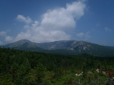
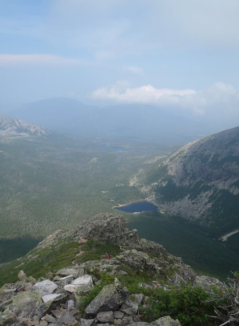
Mt Katahdin is almost exactly a mile high and is just about the only real mountain within a hundred miles. Some West Coast and Rocky Mountain climbers might scoff at the relatively low height of Katahdin but believe me, it is rugged. As you can tell from the above picture, you're looking at a scramble up "Class 3" terrain from most sides. This involves a lot of boulder hopping and hands and feet climbing. Additionally, while summer in the Sierras and Rockies is relatively refreshing, summer climbing up Katahdin involves dealing with extreme humidity coupled with high temperatures and the ever present threat of a summer storm. Again, Katahdin is like a smaller version of Rainer; there are easier ways of getting up it but weather is extremely unpredictable and its prominence relative to its surroundings attracts the storms.
 |
| There are some real climbing routes up the mountain as well |
Having said all this, anyone looking at climbing Mt. Katahdin is in for some panoramic views of New England wilderness and one heck of an adventure!
Hiking Katahdin
Before hiking Mt Katahdin, it is important to make sure you get a permit. Permits may be hard to come by on a busy weekend in July; the state park does a great job of keeping this part of Maine from becoming a disneyland. I'd recommend getting the permit at least two weeks in advance. Additionally, follow the weather patterns before you go up and make sure you have a very sturdy pair of shoes/boots.
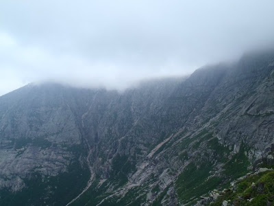
 |
| Massive vertical relief |
Katahdin is located in Maine's Baxter State Park and the park is a well preserved wilderness park which means there are absolutely no forms of technology within the park. Bathrooms are all pit toilets and there are no snack bars along the way like there are on New England's Mt Washington. Also, be prepared for a very long day- the hike is a long one and there is a big elevation change. The good news is that if you bring a way of purifying water, there are many water sources along the way.
Cathedral Ridge and the "Knife's Edge"
There are many ways to get up Katahdin, but I have been told that the Cathedral Ridge to Knife's Edge is one of the best. From the hiking station at the end of Roaring Brook Rd. Here there will be a station to sign in and it is recommended that you do. Again, Baxter State Park is a real wilderness park and there is little help beyond this point. Head on the Chimney Pond Trail for about 3.5 miles. This trail goes through some very deep woods of the park and it will be very hot and humid in the summer. Be prepared for mosquitos as well.
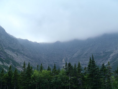 |
| The view of Katahdin at Chimney Ponds |
After a rather uneventful section, you will pop right out on the Chimney Ponds and the foreboding ledges. To the right, you will climb the Cathedral Ledges trail which goes to the right of the ponds. This is where it gets more like a climbing route and less like a hiking route. Blue paint marks the trail and be sure to follow it closely; the talus makes the route somewhat ambiguous if you're not careful. The "cathedrals" are three prominent rocky points along the way- use them as guides when climbing up. This section will take the most time so be patient and chose each step wisely.
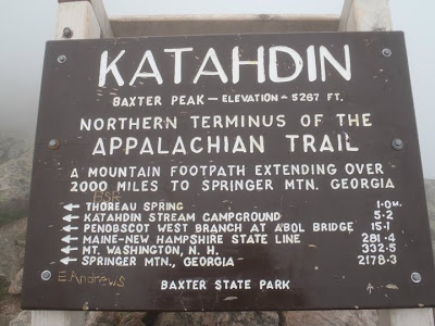
Shortly after the third Cathedral, you will come across the Saddle Trail which takes you directly to the summit. If you go in the summer, you might even see some Pacific Crest Trail thru-hikers coming down from their 2,100 mile journey. This trail is a little flatter and straightforward to Baxter Peak and the top of Katahdin (same thing)
 |
| Can you believe people hike from Georgia to Maine? |
The Knife's Edge is ahead of you and be prepared for the thinnest trail you could ever hike. In this 1.1 mile section you will teeter your way across the fantastically thin ledge that takes you across Katahdin's spine. Again, travel very slowly and be careful where you place each step. Thsoe who have extreme vertigo should travel back the way they came.
After the Knife's Edge I recommend heading down the Helon Taylor Trail which will take you almost directly back to the parking lot where you came from. This is another 3.5 mile long trail which has a more gentle descent compared to Cathedral Ledges. Also, you have wonderful views of the Maine woods which are untouched within Baxter State Park.
 |
| Maine's Untouched Wilderness |
Katahdin is perhaps one of the most difficult hikes in New England and there are many people who underestimate its difficulty. However this should not deter a good hiker from attempting this mountain. Anyone who does will be rewarded with spectacular solitude and beautiful views of New England's wild side. Happy Trails!
Read. Plan. Get Out There!

2 Comments
Kirk
December 12, 2010 @ 23:19
Hey Joe,
Is there a chance I might get a copy of the Baxter state/appalachian trail terminus sign along with any other favs from that hike?! Kirk and I, after over 5 years, are just now putting together our Appalachian trail photo book and because our pics weren't digital the quality isn't good and the pics can't be full size on the book due to the pixels. If you don't mind me borrowing a few of your photocs for the book I would GREATLY appreciate it. Let me know what you think. You can e-mail me at lisah.rn@gmail.com. Hope you are doing well. Love to see all of your adventures!
-Lisa
Joe
December 13, 2010 @ 03:18
Lisa! Yes of course I can give you all my pictures! I took about 100 of them when I climbed Katahdin so you're welcome to use them. I actually don't have the original copies with me but I will get them when I go back up to Nor Cal for Christmas. Thanks for checking out my blog!
-Joe