


How to get to the highest point in Southern California's National Park
Getting to the Trailhead
The best way to approach Quail Mountain is through Joshua Tree's west entrance. This can be reached by driving Highway 62 to the town of Joshua Tree. Once in the park, you will drive all the way past Hidden Valley Campground to the pullout for "Cap Rock". This is roughly 10 miles from the entrance and at the beginning of the intersection for "Keys View". Other sources may give you a route that is a shorter distance, however I believe this route is the best because the actual mountain has a clear line of sight between this parking lot and the summit.
The Route
Its difficult to describe the route itself without a Topographic map, so if you are serious about climbing this mountain, go purchase one. From the "Cap Rock" parking lot, if you look west by northwest, you should be able to see the summit. Note the bearing and head off in that direction. You will be crossing a flat, desert basin for about 2 miles. This section has many Joshua Trees and will lead you to some foothills. Again, remember your original bearing; the foothills will obscure the summit as you approach them.
You will know you are at the top when you see an unnaturally large pile of rocks known as a "cairn". The summit will have sweeping views of Mt San Jacinto and the San Bernardino Mountains and the Mojave Desert. Congratulations, you are at the top of JTree!
Read. Plan. Get Out There!
 |
| Joshua Tree's Best View! |
Quail Mountain is the highest peak of our beloved Joshua Tree National Park. It is the highest point in the park as well as the highest peak in the "Little San Bernardino Mountains". Quail Mountain itself is 5,813ft and a true backcountry adventure for a desert explorer. There are no trails or roads to the top- its entirely cross country and requires very strong compass and map skills. It is not, however, a technical climb- all you will need are supplies for a day and some sturdy boots and pants.
Getting to the Trailhead
The best way to approach Quail Mountain is through Joshua Tree's west entrance. This can be reached by driving Highway 62 to the town of Joshua Tree. Once in the park, you will drive all the way past Hidden Valley Campground to the pullout for "Cap Rock". This is roughly 10 miles from the entrance and at the beginning of the intersection for "Keys View". Other sources may give you a route that is a shorter distance, however I believe this route is the best because the actual mountain has a clear line of sight between this parking lot and the summit.
View Route to Quail Mountain, Joshua Tree National Park in a larger map
The Route
Its difficult to describe the route itself without a Topographic map, so if you are serious about climbing this mountain, go purchase one. From the "Cap Rock" parking lot, if you look west by northwest, you should be able to see the summit. Note the bearing and head off in that direction. You will be crossing a flat, desert basin for about 2 miles. This section has many Joshua Trees and will lead you to some foothills. Again, remember your original bearing; the foothills will obscure the summit as you approach them.
 |
| The long, flat section you cross to get to Quail Mountain (the highest point in the picture is the summit) |
From the bottom of these foothills, you are looking for a saddle that will allow you to pass them without climbing too high. These foothills are not connected to Quail Mountain, so don't try and climb to the top of them.
Once on top of these foothills, you should be able to clearly see Quail Mountain. Study the topography carefully and look for a ridgeline that leads to the summit. It will look like an arm extending in a southeasterly direction from the summit. Descend from the foothills towards this arm, which will take you to the top.
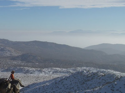
You will know you are at the top when you see an unnaturally large pile of rocks known as a "cairn". The summit will have sweeping views of Mt San Jacinto and the San Bernardino Mountains and the Mojave Desert. Congratulations, you are at the top of JTree!
 |
| A large "cairn" marks the true summit Mt San Jacinto is directy to the left |

No Comments