


Mt. San Jacinto, Southern California
"The view from San Jacinto is the most sublime spectacle to be found anywhere on the Earth!" -- John Muir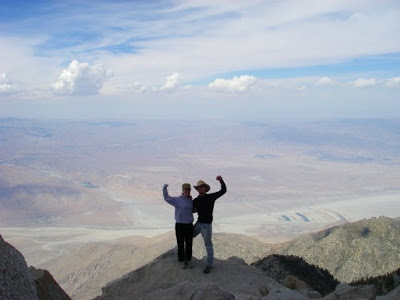 |
| At the summit, I-10 is over two vertical miles below |
When John Muir says something is a "sublime spectacle", you damn well better believe him! From the top of San Jacinto, you can see for over 100 miles. I have stood at the top on a clear day and have been able to see all the way to the ocean and Catalina Island nearly 110 miles away and also could see into Mexico. There is not a view like it anywhere else in the United States. This is because San Jacinto rises from 500ft to 10,800ft in less than 7 miles on the north side. If you were to climb from the desert to the top (which you can), you are climbing more vertical feet than you would climbing Mt Everest from base camp. You literally pass through different biomes as you climb higher. Best of all, it is only about 100 miles from Los Angeles. You can take the tram up for a nice hike to the top or take the ultimate challenge with the "Cactus to Clouds Trail" which has been rated as one of the most difficult hikes in America.
 |
Climbing San Jacinto Peak |
San Jacinto is 2 hours away from LA and Orange County. From Los Angeles, take the same route as you would going to Palm Springs. For most, this would be taking the 60 East to the 215 South, to the 60 East and on to the 10 East. Drive east until you see signs for Palm Springs and Highway 111. Drive South on 111 for about 8.5 miles and turn right at "Tram Way". This will take you to the Aerial Tramway which is the easiest route up the mountain.
From Orange County, take 55 North to 91 East. Drive east on 91 into Riverside and take 60 East to the 10 East and follow the above directions to get to the Tramway.

No Comments